


|
||

|

|
|

|
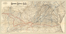
The Luray Inn One Year Prior To Its Destruction By Fire in 1891
Scarce promotional map map of the Valley of Virginia, printed in 1890, commissioned by The Valley Land and Improvement Company.
The map was part of a larger initiative to stimulate land sales in the Roanoke and Shenandoah Valley regions by highlighting the burgeoning transportation networks and the promise of economic growth.
At the center of the map is an illustration of the Luray Inn, depicted to signal the region's readiness for tourism and investment.. The map details the extensive road and railroad lines that connect key urban centers such as Washington D.C., White Sulphur, Roanoke, Lynchburgh, and the Charlestown area. Of particular note is the Baltimore & Ohio Railroad, the lifeline of commerce and transportation that traverses the valley, reflective of the strategic importance of this area in the broader narrative of the United States' industrial expansion.
Luray Inn
The Luray Inn was built in 1883 after designs of George Pearson (1847-1920). The inn has multiple sections, a porch on the right and an octagonal tower on the left. Diagonal lines of latticework decorates the gables of the building and a drive lined with slender trees leads to the front entrance. The Luray Inn was built by the Luray Cave and Hotel Company, a subsidiary of the Shenandoah Valley Railroad. The inn was destroyed by in 1891.
![[ Pictish Man Holding Severed Head ] Picti icon](https://storage.googleapis.com/raremaps/img/small/99837.jpg)
