|
||

|

|
|

|
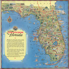
1914 Edition of a Map That Dominated Florida Cartography for Three Decades.
This map of the Florida Peninsula and East Coast Florida railways dominated the popular cartography of that state from 1894 through the 1920s. Published in Buffalo, NY by Matthews Northrup Co., it provided a crucial navigational tool that guided countless travelers traversing the state for three decades.
During the late 19th and early 20th centuries, the evolution of railway networks profoundly reshaped the socioeconomic landscape of the United States. The depicted railway lines and connections, specifically the so-called Flagler System, bear testimony to this transformative period, linking not just towns and cities but also culture and commerce. Henry Flagler's East Coast Railroad, indelibly influenced the development of Florida.
This color-lithographed map does not only focus on the peninsula of Florida but expands its purview to include adjacent islands, as revealed through its insets: a map of the Bahamas and a general map of the southern Caribbean.
See the example held in the Touchton Map Center for further discussion of the dating of the map: luna.tampabayhistorycenter.org/luna/servlet/detail/TBHC~3~3~649~4171:Map-of-the-Peninsula-of-Florida-and
![(The First Letter From British Florida) [September 5, 1763, Autograph Letter, Signed, from Robert Campbell to John Campbell, 4th Earl of Loudoun, describing the British taking possession of Florida and the state of the settlement of Pensacola]](https://storage.googleapis.com/raremaps/img/small/86620.jpg)
![[Florida Keys, Cuba, Bahamas, Cayman Islands] The Island of Cuba with part of the Bahama Banks & the Martyrs . . .](https://storage.googleapis.com/raremaps/img/small/85166.jpg)