|
||

|

|
|

|
Stock# 101832
Description
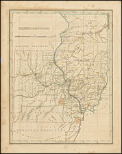
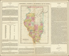
Rare 1869, Chicago-published map of Illinois issued by one of the state's most famous cartographers, Rufus Blanchard.
The map depicts completed and proposed railways; counties are delineated, named, and colored; townships are likewise delineated.
In the upper left corner is a "Topographical Map" showing all the states below Lake Michigan's level.
Condition Description
Lithographed folding map on 19th-century thin wove paper, mounted in original gilt-lettered cloth covers. Original hand-color. Early ink "X" marks throughout the map in brown and purple ink. A few spots, etc. VG to VG+
![[ Auburn Park / Chicago ] Eggleston, Mallette & Brownell's Property](https://storage.googleapis.com/raremaps/img/small/57703.jpg)