|
||

|

|
|

|
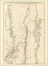
Southern New York During The American Revolution
Scarce map of New York published in London Magazine in 1778.
The map extends from Albany south to Sandy Hook indicating the towns, roads and forts. The detailed depiction of roads is unusual for such a small map.
Colonial boundary lines are shown, with the New York/New Jersey line marked as "settled in 1769" and the Massachusetts/New York line indicated as "not settled."
The map focuses on the Hudson River and The Highlands, showing patents and Dutch place names, including (on the east bank): Mannor of Ranslaerwick; Kinderhook; Claverac; Livingstone; Rhinbec; Kip's Ferry; Crum Elbow; Pakepsy; Wampingess K.; Fish Kill; Martler's Rock; St. Anthony's Nose; Peaks Kill; Courtland Man.; Terrytown; Younker; and New York.
During the Revolutionary War, the local representatives of New York first referred to the "State of New York" in 1776, but British claims on any part of New York did not officially end until the Treaty of Paris in 1783.
![[Last of the Mohicans / New York] Carte dressee pour la lecture du Dernier des Mohicans Roman de J. Fenimore Cooper](https://storage.googleapis.com/raremaps/img/small/86045.jpg)