|
||

|

|
|

|
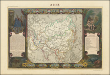
Highly detailed four-sheet map of Asia, produced by London map publishers Robert Sayer and John Bennett, based on the cartography of the famous French cartographer Jean Baptiste Bourguignon d' Anville.
The map provides an extremely detailed view of the continent and extends to include all of Southeast Asia and numerous islands of the Pacific, with emphasis on English discoveries.
While Kamchatka is represented relatively accurately, the North Asian coast is still imprecise. Dutch discoveries are shown in the region north of Japan. The Carolinas are accurately depicted on an east-west axis.
Russian discoveries depict Alaska, which still appears in a very loose archipelagic form, awaiting information from Cook's Third Voyage.
The "Gulf of Corea" is named.
The large decorative cartouche features an Asian merchant, his exotic goods, and a camel.
Robert Sayer (ca. 1724-1794) was a prominent London map publisher. Robert’s father was a lawyer, but his older brother married Mary Overton, the widow of prominent mapmaker Philip Overton and the proprietor of his shop after his death. Mary continued the business for roughly a year after her marriage and then, in early 1748, it passed to Robert. Robert became a freeman of the Stationers’ Company later that year; his first advertisement as an independent publisher was released in December.
Sayer benefited from Overton’s considerable stock, which included the plates of John Senex. In the 1750s, Sayer specialized in design books and topographical prints, as well as comic mezzotints. In 1753, he, along with John Roque, published a new edition of Thomas Read’s Small British Atlas, the first of several county atlases that Sayer would publish.
Sayer’s business continued to grow. In 1760 he moved further down Fleet Street to larger premises at 53 Fleet Street. In 1766, he acquired Thomas Jefferys’ stock when the latter went bankrupt. In 1774, he entered into a partnership with John Bennett, his former apprentice. The pair specialized in American atlases, based on the work of Jefferys. They also began publishing navigational charts in the 1780s and quickly became the largest supplier of British charts in the trade.
Bennett’s mental health declined, and the partnership ended in 1784. As Sayer aged, he relied on his employees Robert Laurie and James Whittle, who eventually succeeded him. He spent more and more time at his house in Richmond. In 1794, he died in Bath.
John Bennett (fl. 1760-d. 1787) was a London printer best known for his role in the successful partnership of Sayer & Bennett. In 1760, Bennett became a servant of Robert Sayer (ca. 1724-1794), the prominent print and map seller, and was apprenticed to him in 1765. In 1774, Bennett became a free journeyman and entered into a partnership with Sayer. They issued joint advertisements and publications. In 1777, Bennett owned 1/3 share in the business. The partnership was likely to continue fruitfully, but in 1781 Bennett began to show signs of mental illness. In 1783, he was admitted to an asylum for nine months and, in 1784, Sayer filed papers to dissolve their business partnership. Bennett died in 1787.
![(Rare copperplate edition!) Asia Secunda Pars Terrae in Forma Pegasi [Asia in the Form of Pegasus]](https://storage.googleapis.com/raremaps/img/small/82046.jpg)
![Asia Secunda Pars Terrae in Forma Pegasi [Asia in the Form of Pegasus]](https://storage.googleapis.com/raremaps/img/small/94173.jpg)
![(Mercator-Hondius Asia) A Leaf from the Mercator-Hondius World Atlas Edition of 1619 with an Essay by Norman J. W. Thrower [with map:] Asia ex magna orbis terre description Gerardi Mercatoris desumpta studio et industria G.M. Iunioris.](https://storage.googleapis.com/raremaps/img/small/101528.jpg)