|
||

|

|
|

|
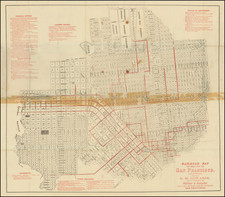
First Printed Map of Alameda, California -- "The Garden of California" (Mark Twain)
Rare early map of the City of Alameda, published less than a year after the incorporation of Alameda on April 19, 1854, based upon a manuscript survey map drawn by Horace Higley for Chipman & Aughinbaugh.
Finely executed cadastral map oriented with north toward the upper left, detailing blocks, lots, and identifying owners of large parcels. The map includes a certification of accuracy and mentions that a portion of the survey was conducted by E. Twitchell. The map compiles work from surveys and maps created by J.E. Whitcher, Benj. L. Jones, James T. Stratton, and Horace A. Higley. Additionally, it incorporates the town of Alameda as it was officially incorporated by the California Legislature on April 19th, 1854.
The map also shows at the right a portion of the town of Encinal.
The map was drawn by Horace Higley, who had been appointed Alameda County's first County Surveyor in 1854. Higley would later go on to become the Surveyor General of California in 1859, before enlisting to fight with the Confederate Army in Mississippi during the Civil War.
This is the second map of Alameda, pre-dated only by a manuscript survey map by James T. Stratton, which survives only in the form of a photocopy in the collections of the Oakland Public Library and UC Berkeley.
Alameda & Encinal
The map includes the adjoining town of Encinal. Before the consolidation into the city of Alameda in 1872, the Alameda peninsula was home to three distinct towns: Alameda, Encinal, and Woodstock.
On October 22, 1851, William Worthington Chipman and Gideon Aughinbaugh bought the peninsula from Don Antonio Peralta. To fund their project, they sold parts of the land but kept the East End. Chipman and Aughinbaugh started out living near Alameda Point. By December, they had assembled a two-story, seven-room house near Peach and Washington Streets. This house was their home for almost three years until Aughinbaugh built his own.
Early settlers in the east end included two French and two Chilean families, alongside many from New England. The area soon had a grocery store, nursery, livery stable, and hotel. Most early residents farmed for a living, but some also worked as doctors, lawyers, or ministers. Within two years, Chipman attracted five clergy members.
Aiming for a city rather than a rural area, Chipman thought of a charter in early 1853. He considered names like “Peralta,” “Leandro City,” and “Elizabethtown” before settling on “Alameda” (Chipman Diary, June 11, 1853). At this time, Alameda's population was similar to Oakland's and San Leandro's.
In May 1853, Chipman hired J.F. Stratton to Survey the town of Alameda, defining it with specific boundaries and laying out blocks and streets, though not all streets were 60 feet wide, most being about 40 feet. He sold lots, measuring 33 feet by 100 feet, at auction in 1854 for about $75 each. Some lots faced north-south streets, with key lots facing cross streets. Chipman was not fully satisfied with Stratton’s survey work due to inaccuracies. The survey began at the peninsula's east end, leading to awkward angles east of Versailles Avenue.
North-south streets were named after legislators and presidents, with other streets named for landmarks or hopes for the future, like Mound Street, Court Street, and Fountain Street. The names reflected local features, aspirations, and possibly the Fountain family.
From its inception, Alameda was meant to be a residential city. Chipman sought to attract groups like athletic clubs and educators by offering free lots. He also donated land for public buildings like the Masonic Temple and churches.
Chipman's charter for Alameda, drafted in 1853, allowed for street openings, sharing costs between the taxpayer and the landowner. However, it required renewal within ten years to accommodate population growth, which did not happen, so the town was governed by the township and county after 1864.
In November 1854, a County Commission inspected the new town, noting the artesian well, plank road, and the only plastered house, owned by C. Holloway. Despite these developments, Alameda's growth was slow, partly due to irregular ferry service to San Francisco, as many residents worked in the city.
The town of Alameda was founded on June 6, 1853. At the time, "Alameda" referred to the village at Encinal and High streets, Hibbardsville was located at the North Shore ferry and shipping terminal, and Woodstock was on the west near the ferry piers of the South Pacific Coast Railroad and the Central Pacific. Eventually, the Central Pacific's ferry pier became the Alameda Mole.
Encinal, established by J. F. Hibbard in the same year, was centered around today's Union Street and Pacific Avenue. Hibbard's investment in 656.6 acres aimed to develop the town along the peninsula's northern shore, introducing a mix of industrial and residential areas.
The unification of these towns into the city of Alameda was spearheaded by Frederick Keller Krauth, a former 49er and newspaper publisher who saw the potential for a single, cohesive community. Krauth's efforts culminated in 1872, transforming the independent towns into one city.
Rarity
OCLC locate 3 examples: UC Berkeley, Oakland Public Library and the Huntington Library.
Provenance: Swann Galleries, December 2023
Born in Pensacola, Florida, Horace Antonio Higley was the eldest son of Horace Loomis Higley and Eualine Collins.
Higley came west during the 1849 California Gold Rush, planning to mine for gold and earn a living as a surveyor.
In California, Higley's reputation as a surveyor burgeoned, culminating in his appointment as the surveyor of Alameda County in the 1854 and later Surveyor-General of the State of California in 1859.
However, the outbreak of the Civil War saw a dramatic pivot in Higley's life. Alongside his three brothers, he aligned with the Confederacy, leaving California in late 1861 for Mobile, Alabama. There, he joined the 40th Alabama Infantry as an ordnance sergeant in August 1862. His military career quickly escalated; by February 1863, he was promoted to major and integrated into the commissary under General William Mackall, eventually serving on General Braxton Bragg's staff as chief of commissary.
In July 1863, during General John Hunt Morgan's infamous raid, Higley was captured after delivering orders from Mackall. He was held as war prisoner in Columbus, Ohio and, after a series of transfers, Higley was finally exchanged in Charleston, South Carolina, in August 1864. Opting not to return to service, he was paroled in Gainesville, Alabama, in May 1865, marking the end of his military engagement.
After the war, Higley returned to California and married Sallie Phole. Heavy drinking resulted in ill health and his death in 1873.
![[ San Francisco / Bay Area ] Welcome Map of San Francisco and the Bay Area](https://storage.googleapis.com/raremaps/img/small/96705.jpg)