|
||

|

|
|

|
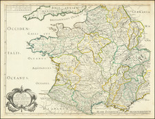
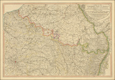
This is a large and detailed overview map shows the progress of the famed Cassini triangulation survey of France, a watershed moment in the development and application of accurate geometrical surveying over large areas.
The map was printed from 18 copper plates on 18 sheets and sometimes is presented in long strips folding out of a quarto binding. Here they have been joined to create four large sheets.
The Cassini Map
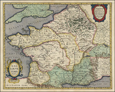
The Cassini Map is the first general map of France prepared on a scientific basis and with geometric precision. It was a monumental cartographic project undertaken by four generations of the Cassini family from the late 17th to the late 18th century. This detailed map was produced through extensive surveying and was a significant achievement in the history of cartography, marking a departure from the more approximative mapping methods previously used.
The project began under the direction of Jean-Dominique Cassini (Cassini I) and was completed by his descendants. It was the first map to cover the whole of France in detail and is notable for its accuracy and the wealth of information it provided, not just on geography but also on the network of roads, towns, and even individual buildings in some cases. The Carte de Cassini is a crucial resource for historians and geographers interested in the historical landscape of France.
Warning
The map carries a fascinating "Avertissement", or warning, in the lower left corner that provides insight into how this new form of mapmaking was received and integrated into existing cartographical knowledge. Here follow a translation into English:
WARNING: Although the main purpose of this Map is only to represent all the places whose position is exactly determined, it has been deemed necessary, while waiting for detailed work to be done on France, to trace the course of the main rivers, and to approximately place the Forests and woods scattered throughout the Kingdom. It is clear that when the direction of a river's course is too far from determined points, reliance had to be placed on various particular Maps of the Provinces, where we have noticed such great variations that one cannot count on the determinations resulting from them. It is also by consulting these same Maps that the Forests and the main woods located around the points of the Triangle were placed, thus one should not be surprised if their location, their size, and their outline are completely misrepresented. This map is composed of 18 plates which will be inserted in the order of the Geometric description of France, which is currently in press. These plates have been arranged in such a way that their assembly can result in a general Map; one must only pay attention when gluing them that all lines, both parallel and perpendicular, always form equal spaces between them, otherwise the joining of the Triangles would be interrupted, and the whole Map would be distorted.

![(France, Belgium, and Holland) Tabula Moderna Francie [Modern Map of France]](https://storage.googleapis.com/raremaps/img/small/101885.jpg)