|
||

|

|
|

|
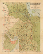
Detailed map of illustrating the travels of Count Eduard Wickenburg in East Africa during the years 1897-98 and 1901-02.
The map, detailed with the routes and observations made by the traveler himself, was prepared by R. Dokaupil, a technical official of the Imperial and Royal Austro-Hungarian Military Geographical Institute.
Eduard von Wickenburg, born to Eduard Ferdinand Matthias Graf von Wickenburg-Capellini and Emilie Wickenburg (de Mignot von Bussy), was a noted explorer and military officer. His early education was completed at the cadet school in Mährisch Weißkirchen, now in the Czech Republic. He left his position as first lieutenant of the Hussar Regiment No. 3 in 1893 to pursue a life of exploration.
Von Wickenburg's travels were extensive and took him across multiple continents. His expeditions included journeys to Asia, North America, and Africa. Notably, in 1901, he embarked on a significant research trip to Abyssinia, under the auspices of the Imperial and Royal Geographical Society in Vienna. Starting from Djibouti and ending in Lamu in British East Africa, he covered a remarkable 3,700 kilometers, venturing into regions previously unexplored by Europeans. His contributions to cartography include the naming of Mount Wickenburg in Kenya, known locally as Forole.
His earlier expeditions, from 1893 to 1896, had taken him to various destinations including India, Ceylon, Australia, Siam, Indochina, the Malay Peninsula, Sumatra, Java, China, Japan, and the North American continent.
Tragically, in 1936, Eduard von Wickenburg disappeared while on a tour in the Höllengebirge during a summer stay in Gmunden and was never found.
August Heinrich Petermann (1822-1878) is a renowned German cartographer of the nineteenth century. Petermann studied cartography at the Geographical Art-School in Potsdam before traveling to Edinburgh to work with Dr. A. Keith Johnston on an English edition of Berghaus’ Physical Atlas. Two years later he moved to London, where he made maps and advised exploratory expeditions as they set off to explore the interior of Africa and the Arctic.
In 1854, Petermann returned to Germany to be Director of the Geographical Institute of Justus Perthes in Gotha. There, he was the editor of the Geographische Mittheilungen and Stieler’s Handatlas. The Royal Geographical Society of London awarded him their Gold Medal in 1860. He continued his interest in exploration in Germany, fundraising for the German Exploring Expeditions of 1868 and 1869-70, which sought an open Arctic sea. Tragically, he committed suicide in 1878.
![[Lake Tanganyika, Lake Victoria and Northwest Tanzania]](https://storage.googleapis.com/raremaps/img/small/63611.jpg)
![[ With Unusual Annotations in Red ] A Draught of the South Part of Africa from Cape Bona Esperance to Delagoa](https://storage.googleapis.com/raremaps/img/small/99414.jpg)