


|
||

|

|
|

|
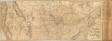
Mapping Manifest Destiny
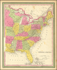
Nice example of AH Brue's early map of the United States, issued after the Adams Onis Treaty and the confirmation of the United States's claims to extend from coast to coast.
The map is especially interesting for its treatment of the Tranmississippi West, including the expanses of Texas, New Mexico and Upper California, which are still part of the newly Independent Mexican nation. The map details the early discoveries of Lewis & Clark and Zebullon Pike, expedition which had been sent out by Thomas Jefferson shortly after the Louisiana Purchase, as well as the subsequent expedition of Stephen Long and the privately sponsored expedition of Hunt & Stuart, which traversed what would later become known as the Oregon Trail on behalf of John Jacob Astor's venture to establish a trading presence on the Pacific Coast (Fort Astoria).
The map also reflects the 1818 compromise between the British and the Americans over their joint control of large swaths of the Oregon Country, which would not be resolved for another 2 decades. Here the map illustrates a very pro-American configuration of the boundary, place the entire Fraser River watershed and contiguous regions up to 54º40" north latitude within the United States.
The map also provides an elegant treatment of the many mythical rivers of the West and introduces the two salt lakes, Timpanogos and Teguayo, in what would become Utah. From Lake Timpanagos, two mythical rivers flow west, crossing regions which would later be determined to be quite mountainous, including the rare appearance of the speculative "Rio de los Mongos" or "Jos. Millar" river on the Mexico-US Border. The reference to the Rio de los Mongos derives from Escalante and Humboldt and would ultimately become the Multnomah River.
Further south, two more rivers flow speculatively from the general direction of Lake Teguayo toward the California coastline, while in Southern California, the mythical R. de los Martiers and extends from somewhere near Las Vegas to the San Luis Rey River (and Mission) in North San Diego County, with an even more curious dotted line shown from the southern tip of San Diego pay drifting generally northwest, suggesting a tentative political division.
The map is one of the most detailed renderings of the drainage systems of the Rockies and Upper Mississippi prior to Nicollet. Several early forts are shown in Texas. The Missions and early mythical rivers shown in California.
In sum, a remarkably detailed early mapping of the Transmississippi West.
Andre Hubert Brué was a French geographer and cartographer. Born in Paris, he served in the French Navy, joining the Baudin expedition to the Pacific (1800-1804). After his sea service, Brué applied his navigation and charting skills to creating finely-crafted maps, which were renowned for their crisp engraving and accuracy. He drew directly on the copper of the plate, creating what he called encyprotypes. He is best known for the Atlas universal de géographie physique, politique, ancienne et moderne.
![Die Vereinigten Staaten von Nord Amerika (Ostlicher Theil) [New York City Inset]](https://storage.googleapis.com/raremaps/img/small/62359.jpg)