|
||

|

|
|

|
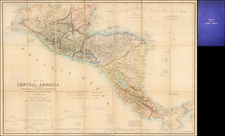
The First Official Map of Nicaragua
Rare early map of Nicaragua, published in New York by G. Kraetzer; and J. Rau, 1859.
The map was issued shortly after the end of Nicaragua's filibuster period and immediately prior to the Treaty of Managua, during the period when the wealthiest nations of the world were focused on the prospect of creating transit routes or a canal across Central America, as a means of improving commerce by sea. The California Gold Rush and trade with East Asia had created a far more significant demand for fast transit between the Atlantic Ocean and the Pacific Ocean and construction had only just begun on the Suez Canal.
Focused on the topographical features of Nicaragua and highlighting is massive inland lakes, the map also includes town plans of the cities of Leon, Granada, and Viejo Leon, along with 4 profile sections showing the topographical features of the country.
The map is based on meticulous itinerant surveys by Maximilian von Sonnenstern, a German engineer and recent immigrant who is regarded as the progenitor of modern Central American cartography. It presents a meticulously detailed and largely precise depiction of the country's populated western and southern regions. This map emerged as a crucial strategic tool for national development following the Nicaraguan Civil War of 1854-1858, positioning it as one of the cornerstone documents of the nascent republic.
Nicaragua
The history of Nicaragua in the 19th century is a complex tapestry of conflict, political upheaval, and the struggle for sovereignty, characterized by key figures, wars, and significant treaties.
1821 - Independence and Union with the Federal Republic of Central America Nicaragua, along with other Central American provinces, declared independence from Spain on September 15, 1821. This marked the beginning of its contemporary nationhood. Shortly after, it became a part of the Federal Republic of Central America in 1823, which included present-day Costa Rica, El Salvador, Guatemala, Honduras, and Nicaragua.
1838 - Disintegration of the Federation and Emergence as a Sovereign State The Federal Republic was marked by internal strife and regional conflicts. In 1838, Nicaragua formally withdrew from the federation, becoming fully independent.
1855 - William Walker and the Filibuster War One of the most pivotal episodes was the intervention of American filibuster William Walker, who arrived in Nicaragua in 1855. He capitalized on the Liberal-Conservative civil war and, with the support of the Liberals, took control of the government. In 1856, he declared himself president, aiming to establish English-speaking dominance in Central America.
1856-1857 - National War Against Filibusters The occupation by Walker was met with strong opposition from Nicaraguans and neighboring countries. A coalition of Central American armies fought against Walker in the National War, which lasted until 1857, culminating in his defeat and eventual execution in 1860.
1860 - Treaty of Managua Nicaragua's sovereignty was further solidified by the Treaty of Managua in 1860, which ended British claims over the Mosquito Coast, an area on the eastern shore of Nicaragua and Honduras.
Rarity
The map is very rare on the market.
Provenance: Swann Galleries: December 2023

![[Galapagos] Carte de la Cote Occidentale D'Amerique Comprise Entre Le Golfe de Tehuantepec et le Golfe de Guayaquil (Amerique Centrale, Nlle Grenade, Equateru) . . . .1864](https://storage.googleapis.com/raremaps/img/small/57942.jpg)
![[ Yucatan ] Pas-kaart Van de Golff de Guanaios Met 't Canaal Tusschen Yucatan en I. Cuba . . .](https://storage.googleapis.com/raremaps/img/small/99320.jpg)