


|
||

|

|
|

|
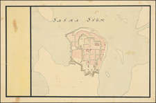
This remarkable 18th-century manuscript map, overseen by Axel Magnus von Arbin, offers an exquisite depiction of the northern vicinity of Stockholm, capturing both the city proper and its expanding suburbs. Encompassing areas that today include Sundbyberg, Råsunda, Solna, and Hallonbergen, the map provides a detailed illustration of the region as it was in the mid-18th century, a period of significant urban and rural development within the Swedish capital.
The map’s historical context is deeply intertwined with the urban expansion of Stockholm during the 18th century, a time when Sweden was undergoing considerable changes in its social, economic, and political spheres. The delineation of areas such as Karlberg, with its notable gardens just west of the city's bounds, underscores the evolving landscape surrounding Stockholm. In 1793, Karlberg Palace was repurposed as a military academy. This era was marked by the gradual outward growth of the city, reflecting broader European trends of urban development and the increasing importance of detailed cartographic records for military, administrative, and economic purposes. Interestingly, the city itself has remained rather fixed at the boundary shown on the map, while suburbs has substantially infilled.
Axel Magnus von Arbin's exacting documentation through this map illuminates the intricate relationship between Stockholm's urban core and its periphery. His particular attention to land cover, represented through illustrative styles depicting trees, fields, and dozens of small villages, complete with their names and the layout of buildings and roads, provides invaluable insights into the land use and architectural heritage of the period. Such cartographic details not only offer a window into the 18th-century landscape but also serve as a testament to the mapmaking artistry of the time, capturing the essence of Stockholm's natural and built environment with precision and aesthetic sensitivity.
Von Arbin would rise to the rank of Lieutenant General and Director of the Royal Fortifications, a subject on which he published several books. This map could very well have been produced as part of his responsibilities for the fortification of Stockholm.
![[ Southern Baltic Sea ] De Custen van Schoonen en Swede van Valsterboen tot Christianopolis Bornholm en de Custen van Pomeren van't Eylant Rugen tot Rygs-hooft](https://storage.googleapis.com/raremaps/img/small/67743.jpg)
![[ Gotland ] Geo=Hydrographisk Chara ofwer Provincen Gothland](https://storage.googleapis.com/raremaps/img/small/101581.jpg)