|
||

|

|
|

|
Stock# 101658
Description
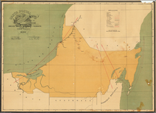
Glorious large, illustrated map of the Yucatan Peninsula, published in Paris.
The map includes portraits of Porfirio Diaz (President of the Republic of Mexico) and Olegario Molino (Governor of Yucatan), as well as 12 images of important buildings in the Yucatan, including:
- Executive Palace in Merida
- Ruins in Uxmal
- Merida Cathedral
- Asilo Ayala in Merida
- A Public Well in Campeche
- Lerma Beach, Campeche
- Fishing Village in Campeche
- Merida City Hall
- Grand Hotel in Yucatan
- Campeche Cathedral
- Labna Ruins in Yucatan
- New Merida Hospital
The legend provided details various symbols used to represent different features and elements on the 1907 map of the Yucatan:
- Capital de Estado (State Capital): Illustrated by a circle with a central dot.
- Ciudad (City): Denoted by a circle.
- Villa (Town): Shown as a smaller circle.
- Pueblo (Village): Indicated by a tiny circle.
- Lugar sin habitantes ó Sitio (Uninhabited Place or Site): A dashed line.
- Ruinas (Ruins): Represented by a cross (+).
- Hacienda ó Ranchería (Hacienda or Hamlet): Illustrated by a dot.
- Puerto de Altura (Seaport): Symbolized by an anchor.
- Puerto de Cabotage (Cabotage Port): Shown with a smaller anchor.
For transportation and infrastructure:
- Camino de fierro (Railroad): Represented by a solid black line.
- id en construcción (Railroad under construction): A dashed red line.
- Camino carretero (Main Road): Illustrated by a thick black line.
- id particular ó vereda (Private Road or Path): A thin black line.
Geopolitical boundaries:
- Límite de República (National Border): A dashed line with cross symbols.
- id de Estado (State Border): A dashed line.
- id de Partido (District Border): A dot-dash line.
Communication lines:
- Líneas telegráficas (Telegraph Lines): A blue line.
- id Teléfonicas (Telephone Lines): A red line.
Land types:
- Terrenos pedregosos para el cultivo del henequen (Stony Grounds for Henequen Cultivation): A pink area with dots.
- Terrenos llanos propios para el cultivo de la caña dulce, tabaco, frijol, maíz, yuca, ságu, & (Flatlands suitable for the cultivation of sugarcane, tobacco, beans, corn, yucca, sago, etc.): A yellow area.
- Terrenos cenagosos y boscosos donde abundan maderas preciosas de construcción y de tinte (Swampy and wooded areas where precious construction and dye woods abound): A green area.
Rarity
OCLC locates a single example: El Colegio de Mexico A.C.
Condition Description
Minor loss at folds. Some old tape reinforcements on verso.
![[ Cabo San Lucas, Southern Baja ] Delineatio Nova Et Vera Partis Australis Novi Mexici, cum Australi Parte Insulae Californiae Saeculo Priori ab Hispnis Detectae.](https://storage.googleapis.com/raremaps/img/small/95666.jpg)
![(Humboldt Atlas and Text) Geographique et Physique du Royaume de Nouvelle-Espagne [with quarto text:] Essai Politique de la Royaume de la Nouvelle-Espagne](https://storage.googleapis.com/raremaps/img/small/99796.jpg)