|
||

|

|
|

|
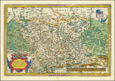
Lizars map offers a detailed look into this interesting moment in German history. During this era, the landscape of Central Europe was a patchwork of sovereign states and territories, a vestige of the Holy Roman Empire, which had been dissolved in 1806.
A significant portion of the map is dedicated to the territories held by the Kingdom of Prussia. By the 1830s, Prussia was a major European power, having territories stretching from modern-day western Poland to parts of western Germany. Alongside the Prussian dominions, the German Confederation, established by the Congress of Vienna in 1815, was a loose association of 39 German-speaking states in Central Europe. The map would have highlighted the major states, including Bavaria, Saxony, Hanover, and Württemberg, among others.
From 1820 to 1840, the region experienced a series of significant events and changes. In the Kingdom of Prussia, Frederick William III (1797-1840) reigned throughout this period. His rule witnessed significant reforms in the Prussian military, administration, and education systems. Each of the German Confederation states had its own ruler, such as King Ludwig I of Bavaria (1825-1848) and King George IV of Hanover (1820-1830), followed by William IV (1830-1837).
The Congress of Aix-la-Chapelle in 1818 ended the occupation of France and readmitted France to the Quintuple Alliance. Although it didn't directly concern the German territories, the diplomatic processes and discussions influenced the political climate of Europe. Additionally, the Hambach Festival in 1832 was a pivotal event, a German national democratic festival that reflected growing nationalistic sentiments in the German states.
Furthermore, several wars in the neighboring regions impacted the political dynamics in Germany. The Belgian Revolution from 1830 to 1839, although not a direct German conflict, had implications for the German states because of the territorial negotiations. The Polish November Uprising against the Russian Empire in 1830-1831 also held significance for Prussia, which shared a border with the Russian-held Polish territory.
The Lizars were a Scottish family of engravers and printers who produced many views and maps. Daniel Lizars Sr. (1754-1812) was the son of a shoemaker, but he apprenticed with Andrew Bell, a printer and engraver. Lizars set up his own printworks near St. Giles Cathedral and took on his own apprentices, including George Bartholomew, whose son John would go on to found the important mapmaking firm later know as John Bartholomew & Son Ltd.
Daniel Sr. had three sons: Daniel Jr., John, and William Home. He also had a daughter, Jane Home. Daniel Jr. (1793-1875), the youngest of the boys, apprenticed in his father’s shop alongside George Bartholomew. When his father died in 1812, Daniel Jr. took over much of the business, expanding it and specializing in maps. The company went bankrupt in 1832, however, and Daniel emigrated to Canada.
John Lizars (1792-1860), the middle son, studied medicine and became Professor of Surgery at the Royal College of Surgeons of Edinburgh, as well as senior surgeon at the Royal Infirmary of Edinburgh.
William Home Lizars (1788-1859), the eldest, also apprenticed in his father’s shop. After learning engraving, William entered the Trustees’ Academy to learn under John Graham. He was a skilled painter and artist. When his father died, and after his Daniel Jr. left, he carried on printing and invented a method of etching that looks like wood engraving.
![[Riga & Environs]. Der Rigische Kreis / Le Cercle de Riga](https://storage.googleapis.com/raremaps/img/small/69148.jpg)
![(Second World War - Eastern Front) [The Soviet Encirclement of Konigsberg]](https://storage.googleapis.com/raremaps/img/small/65659.jpg)