


|
||

|

|
|

|
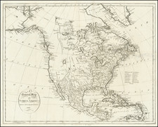
One of the first atlas maps of North America published in America, from Reid's American Atlas, the second Atlas published in the United States.
The map shows the region on the eve of the explorations of Lewis & Clark, Zebulon Pike and others who would open up the Transmississippi West. Only the earliest hint of the Rocky Mountains is present.
Nice detail along the Northwest Coast of America, but little detail off the coast.
Massive unnamed lake near Salt Lake City, which would become Lake Timpanogos.
Annotations
See Cook's Voyages
Morse's Geography
Portlock & Dixon's Voyages
The land is full of Mountains, the tops of which are covered with snow while the vallies between and the ground on the sea coast high as well as low are covered with trees which form a beautiful prospect as one vast Forest. There people are more tenacious of property than any of the savage nations and were sometimes very unreasonable in their demands.
The northwestern border of the United States has been consciously drawn to Lake Winnipeg.
Following Mathew Carey’s publication of the American Atlas in 1795, the second large format atlas published in America was produced by John Reid of New York in 1796. The project began as an atlas to accompany William Winterbotham’s An Historical, Geographical, Commercial and Philosophical View of the United States, but was also sold separately under the title The American Atlas.
Reid’s atlas included 20 maps. In addition, John Russell’s plan of Washington, D.C. is also bound into some copies of the Atlas. Reid’s atlas was a collaborative work, with 9 of the maps engraved by Benjamin Tanner, 5 by David Martin, two by D. Anderson and one each by John Scoles and John Roberts. Two of the maps do not include engraving credits. Each of the engravers was probably working in New York (including Tanner, who had not yet relocated to Philadelphia). According to the various entries for the maps in Wheat & Brun, the cartographic content of the maps is drawn largely from Carey’s first atlas of 1795.
![[ First State of the First Map of America ] Novae Insulae XVII Nova Tabula](https://storage.googleapis.com/raremaps/img/small/94609.jpg)
![[Pan American Menu Map] North America](https://storage.googleapis.com/raremaps/img/small/103976.jpg)

![[The Rarest State] Americae Sive Novi Orbis Nova Descriptio](https://storage.googleapis.com/raremaps/img/small/80521.jpg)