|
||

|

|
|

|
Stock# 101488
Description
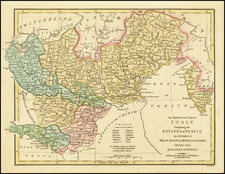
Detailed late-18th-century map of the Veneto and region east of the Adige River, centered on Padua. The map was reissued by Remondini in Venice after having been initially produced by Paolo Santini.
The map shows Venice, Padua, and Vicenza.
The title credits Paul Barthelemi Clarici with the cartography.
Condition Description
Engraving on 18th-century laid paper. Original hand-color in outline.
Paolo Santini Biography
Paolo Santini (1729-1793) was an Venetian engraver known especially for his religious prints and fine cartographic engravings. He published in Venice and may have a been a member of the clergy. In his maps, he largely adopted and adapted the work of his French counterparts, especially the brothers de Vaugondy.
![[Padua, Treviso] Patavini Territoriorii, Corographia, Iac. Castaldo Auct. [with] Tarvisini Agri Typus](https://storage.googleapis.com/raremaps/img/small/83544.jpg)
![[ Tyrolia] A New Map of the County of Tyrol, And the Republic of Venice; Duchy of Mantua &c &c . . . 1799](https://storage.googleapis.com/raremaps/img/small/101127.jpg)