|
||

|

|
|

|
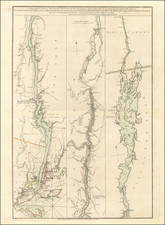
Nice example of John Reid's map of Vermont, the second folio map of the state to appear in a commercial atlas.
The map is drawn largely from Mathew Carey's map of Vermont, which is considered the first folio atlas map of the state, which was in turn engraved by Amos Doolittle. This edition was engraved by Roberts.
The map shows 7 counties, townships, rivers, mountains, lakes, roads, etc.
An essential map of Vermont collectors.
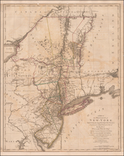
John Reid's American Atlas was the second folio sized atlas published in the US. Reid's atlas was originally issued to accompany Winterbotham's Historical, Geographical, Commercial and Philosophical View of the United States. It was originally issued with 20 maps, which were engraved by Benjamin Tanner (9), David Martin (5), D. Anderson (2), John Scoles and John Roberts. Two of the maps are without credits.
Manuscript
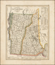
In the title, a note: Vermont "admitted into the Union 4th March 1791."
The State of N.Y. obtained a decree in 1766 that the eastern boundary of N.Y. after passing Connt. + Massachusetts Bay should be Connecticut River. This decree annexed to the Jurisdiction of N.Y. a tract of land 80 miles in width + two hundred in breadth which contained 960 Townships of 6 miles square _ all the state of Vermont (History of Connt. by a gentleman of the province page 104.105).
This line is 20 miles of Hudson.
The westernmost head of this river is the boundary line of the United States Treaty of Peace.
Following Mathew Carey’s publication of the American Atlas in 1795, the second large format atlas published in America was produced by John Reid of New York in 1796. The project began as an atlas to accompany William Winterbotham’s An Historical, Geographical, Commercial and Philosophical View of the United States, but was also sold separately under the title The American Atlas.
Reid’s atlas included 20 maps. In addition, John Russell’s plan of Washington, D.C. is also bound into some copies of the Atlas. Reid’s atlas was a collaborative work, with 9 of the maps engraved by Benjamin Tanner, 5 by David Martin, two by D. Anderson and one each by John Scoles and John Roberts. Two of the maps do not include engraving credits. Each of the engravers was probably working in New York (including Tanner, who had not yet relocated to Philadelphia). According to the various entries for the maps in Wheat & Brun, the cartographic content of the maps is drawn largely from Carey’s first atlas of 1795.
![[ Battle of Saratoga ] Plan of the Position which the Army under Lt. Gen. Burgoine took at Saratoga on the 10th of September 1777 and in which it remained till the Convention was signed.](https://storage.googleapis.com/raremaps/img/small/103578.jpg)