


|
||

|

|
|

|
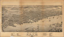
This map, produced from a trigonometrical survey under A.D. Bache and Benjamin Peirce from 1852 to 1869, illustrates a detailed segment of the Maine coastline from Penobscot Bay to Kennebec Entrance. The chart, part of the comprehensive surveying project of the United States Coast Survey, showcases the advanced mapping techniques of the mid-19th century and the government's commitment to accurate coastal charting for navigational purposes.
Covering locations such as Thomaston, Waldboro, Damariscotta, Newcastle, Wiscasset, and Bath, this chart provides a historical snapshot of the Maine coastline. Its detailing of topographical and hydrographical aspects offers insight into the region's geography during the late 19th century, serving as a historical record of the Northeastern United States.
![[ The Finest Colonial New England Sea Chart of the 18th Century ] The Coast of New England](https://storage.googleapis.com/raremaps/img/small/63672.jpg)

![[ Cape Cod to Acadia ] Pas-Kaart Vande Zee Kusten inde boght van Niew Engeland Tusschen de Staaten Hoek en C.de Sable . . .](https://storage.googleapis.com/raremaps/img/small/94453.jpg)