


|
||

|

|
|

|
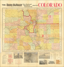
The exceedingly rare second state of Louis Nell's map of Colorado, the most complete of Colorado to appear after statehood (1876).
Nell's map meticulously depicts the geographical and topographical details of the state, including mountain elevations. The map is hand colored by counties, and delineates private grants and military reservations. Townships which have been subdivided and townships which have only been surveyed are also shown.
The map details the wagon roads, trails, and railroads both existing and proposed, along with details for rivers, creeks and even seasonal watershed which are dry during the majority of the year.
Nell's work vastly surpasses the work of earlier mapmakers such as Thayer, both in scale and detail, and was updated regularly. For example, in the present edition, the map shows the new town of Telluride, which had been founded as Columbia in 1878, but changed its name to Telluride in 1881.
Louis Nell was, without question, the most important Colorado mapmaker of the late 19th and early 20th Century, with his separately published maps of Colorado dominating the market for three decades. Prior to becoming a commercial mapmaker, Nell was active as a surveyor on the 1871-1879 Wheeler Surveys and gained a significant amount of information from this work, which he ultimately employed in producing what is without doubt the best large format map of the state of the period and became a huge commercial success.
![The Seasoned Traveler Goes By Train [Map of Denver and Rocky Mountain National Park]](https://storage.googleapis.com/raremaps/img/small/99861.jpg)

![[Poster] IBM Advertising - Boulder, Colorado](https://storage.googleapis.com/raremaps/img/small/78793.jpg)