|
||

|

|
|

|
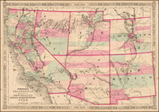
Rare large folio atlas map of California by George F. Cram from the 1878 edition of his railroad atlas.
The map documents the early phase of railroad expansion in Southern California.
A large Tulare Lake and associated wetlands are still shown in the southern Central Valley.
Some counties, such as Orange, Riverside, and Imperial, have not yet been created.
Much of Nevada, including Las Vegas, is shown to the east of California.
Rarity
The early Cram railroad atlas maps are rare. This is the first time we have offered the map for sale (1992-2024).
George F. Cram (1842-1928), or George Franklin Cram, was an American mapmaker and businessman. During the Civil War, Cram served under General William Tecumseh Sherman and participated in his March to the Sea. His letters of that time are now important sources for historians of the Civil War. In 1867, Cram and his uncle, Rufus Blanchard, began the company known by their names in Evanston, Illinois.
Two years later, Cram became sole proprietor and the company was henceforth known as George F. Cram Co. Specializing in atlases, Cram was one of the first American companies to publish a world atlas. One of their most famous products was the Unrivaled Atlas of the World, in print from the 1880s to the 1950s.
Cram died in 1928, seven years after he had merged the business with that of a customer, E.A. Peterson. The new company still bore Cram’s name. Four years later, the Cram Company began to make globes, a branch of the business that would continue until 2012, when the company ceased to operate. For the final several decades of the company’s existence it was controlled by the Douthit family, who sold it just before the company was shuttered.
![(California Gold Rush) Oregon and California in 1848 in Two Volumes [with:] Map of California, Oregon, Texas, and the Territories adjoining with Routes &c.](https://storage.googleapis.com/raremaps/img/small/82901.jpg)
![[ Imperial County / Annotated by County Surveyor ] Denny's Pocket Map of Imperial County](https://storage.googleapis.com/raremaps/img/small/87140.jpg)