|
||

|

|
|

|
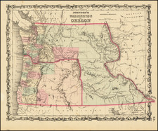
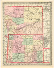
The First Separately Published Atlas Map of Idaho Territory
Rare 1878 edition this important early map of Idaho Territory, published by George Cram in Chicago.
Idaho has only 10 counties, although the boundaries are very unusual. Pre-dates the formation of Washington County, Cassia County and Bear Lake County (all formed in February 1879) and showing the now extinct Alturas County.
Some early township surveys are shown in the west around Palous Bridged and Coeur D'Alene, Lewiston and the Boise areas.
Cram's map of Idaho Territory is the earliest separately published map of Idaho, having been issued separately beginning in 1875 and in the rare pre-1880 editions of Cram's atlas.
George F. Cram (1842-1928), or George Franklin Cram, was an American mapmaker and businessman. During the Civil War, Cram served under General William Tecumseh Sherman and participated in his March to the Sea. His letters of that time are now important sources for historians of the Civil War. In 1867, Cram and his uncle, Rufus Blanchard, began the company known by their names in Evanston, Illinois.
Two years later, Cram became sole proprietor and the company was henceforth known as George F. Cram Co. Specializing in atlases, Cram was one of the first American companies to publish a world atlas. One of their most famous products was the Unrivaled Atlas of the World, in print from the 1880s to the 1950s.
Cram died in 1928, seven years after he had merged the business with that of a customer, E.A. Peterson. The new company still bore Cram’s name. Four years later, the Cram Company began to make globes, a branch of the business that would continue until 2012, when the company ceased to operate. For the final several decades of the company’s existence it was controlled by the Douthit family, who sold it just before the company was shuttered.
![[Great Falls, Montana] Great Falls, Montana Size of Lots 50' x 150'](https://storage.googleapis.com/raremaps/img/small/85587.jpg)