|
||

|

|
|

|
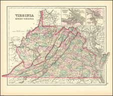
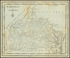
Rare late edition of T.G. Bradford's map of Virginia (including what is today Virginia and West Virginia), published in 1846.
The map is hand colored by counties and shows very early railroads, towns, rivers, forts, post offices, and other details.
Bradford's atlas was a departure from other atlases of the period. Along with H.S. Tanner, Bradford produced an elegant, well-engraved, large format atlas on high-quality paper.
The map was engraved by G.W. Boynton.
Thomas Gamaliel Bradford (1802-1887) was an American geographic publisher. He hailed from Bradford, Massachusetts and began his publishing career by working for the America Encyclopedia. Then, he edited and republished the Atlas Designed to Illustrate the Abridgement of Universal Geography, Modern & Ancient, which had originally been offered in French by Adrian Balbi. In 1835, he published another atlas, A Comprehensive Atlas: Geographical, Historical & Commercial, and, in 1838, An Illustrated Atlas Geographical, Statistical and Historical of the United States and Adjacent Countries. His interests were primarily in educational publishing and he was one of the first mapmakers to show Texas as an independent country.
![[ 20 Historical Border Survey Maps Tracking The History of Pennsylvania's Borders ]](https://storage.googleapis.com/raremaps/img/small/96836.jpg)