


|
||

|

|
|

|
Stock# 100946
Description
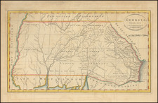
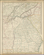
Nice example of this early regional map of Georgia and parts of the neighboring states, showing the early counties, towns, roads and Indian details.
The northwestern portion of Georgia is still largely unsettled Cherokee land without counties. Northeastern Alabama is dominated by Creek lands. One of the southern counties of Tennessee is also unnamed. Many forts, Indian villages and other landmarks identified throughout the map. Information key notes abbreviations for bridges, court houses, churches, creeks, forks, lakes, mountains, post offices points, springs, swamps & villages, Indian villages, forts, etc.

![[ Tennessee / Louisiana / Mississippi / Alabama ] Boston Mountains (408) Radar AAF Aeronautical Chart](https://storage.googleapis.com/raremaps/img/small/97161.jpg)
