|
||

|

|
|

|
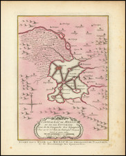
Interesting map of Mexico and the West with details by Simon A. G. Bourne, Esq.
The map shows the west shortly after the Treaty of Guadalupe Hidalgo. Texas and New Mexico are shown prior to the Compromise of 1850, and Upper California dominates the west, pre-dating Utah Territory.
Bourne, closely connected with James Long, Arthur Wavell, and Benjamin Milam, all key figures with vested interests in Texan lands, brings a wealth of regional knowledge to this work. His several-year sojourn in Mexico and Texas, possession of Austin's 1822 map, and his 1828 published brief on Texas, enrich this map with authentic details, particularly in its representation of Texan rivers and settlements.
The endeavors of T. Haden Edwards, Daniel Stuart, Simon Bourne, and Robert Leftwich in the early 19th century significantly influenced the American settlement in Texas, a region then under Mexican rule. This period marked a critical juncture in the history of Texas, characterized by diplomatic negotiations, land grants, and the challenging task of mapping uncharted territories.
T. Haden Edwards, a prominent figure in early Texan history, was known for his efforts in securing permission for American settlement in the region. Along with his associates, including Daniel Stuart, Simon Bourne, and Robert Leftwich, Edwards navigated the complex political and geographical landscape of Texas. Their collective efforts were geared towards establishing a legal and practical framework for American emigration and settlement under the Mexican government.
Simon Bourne served as the Mayor of Yngles in 1821. By the 1820s, he was actively involved Texas colonial history In 1822, Stephen F. Austin, drew a map to accompany his petition for the confirmation of his empresario contract with Mexican authorities, which Bourne in turn improved and updated in a marvelous manuscript example.
Bourne enhanced the map's accuracy and detail, particularly in depicting the major rivers, towns, and roads in Texas, stretching from the Rio Grande to the Sabine River.
![[Charles Lindbergh - 1st Trans-Atlantic Flight - Printed on Linen]](https://storage.googleapis.com/raremaps/img/small/69233.jpg)
![Map of Mexico, Central America, and the West Indies [Insets of Bermuda, Sandwich Islands, Jamaica and Panama Railroad]](https://storage.googleapis.com/raremaps/img/small/78369.jpg)
![[ Military Departments ] Johnson's New Military Map of the United States Forts, Military Posts & all the Military Divisions with Enlarged Plans of the Southern Harbors . . .](https://storage.googleapis.com/raremaps/img/small/101114.jpg)
![(Mexican-Aztec Artwork) [Original pencil tracing of Aztec Calendar]](https://storage.googleapis.com/raremaps/img/small/102327.jpg)