|
||

|

|
|

|
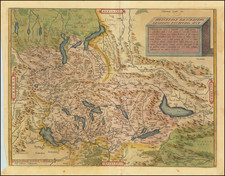
Early Swiss Mountaineering Map
Early 20th-century topographical map of the Swiss Engadin Valley.
The historical significance of the Engadin Valley, captured in this map, is rooted in its geological and cultural landscape. Known for its rugged beauty and therapeutic springs, the valley was a subject of interest to both natural scientists and those in the emerging field of leisure tourism.
An early notice in Alpina (1916), noted:
The map, which is kept in the manner of similar special maps, will be a valuable guide for the numerous visitors to that region blessed with scenic beauty. Particularly of interest to the mountaineer is the depiction of the promising and easily accessible Piz Lischana with its magnificent surroundings, as well as the Pisoc group, composed of bold peaks.
"Piz Lischana" is part of the Sesvenna Range, in the Eastern Alps. The Sesvenna Range lies on the border between Switzerland and Italy. "Pisoc group" likely refers to a grouping of peaks in the vicinity of Piz Pisoc, which is the highest mountain in the Sesvenna Range. Piz Pisoc is a well-known peak in the Swiss National Park and is a popular destination for mountaineers.
The cartographic techniques employed demonstrate a commitment to accuracy and detail. Contour lines and color gradations provide a clear understanding of terrain and elevation, essential for early 20th-century explorers and visitors. The delineation of roads, paths, and settlements conveys a snapshot of the infrastructure at a time when the region was becoming accessible to a broader public.
As a cultural record, the map shows the development of tourism in the Engadin Valley. The routes connecting Tarasp, Schuls, and Vulpera indicate the emergence of these locations as destinations. The presence of transportation routes also marks the integration of this once remote area into the broader mobility network of the time.
Rarity
The map is unrecorded.
![[Lake Neuchâtel]](https://storage.googleapis.com/raremaps/img/small/73670.jpg)