|
||

|

|
|

|
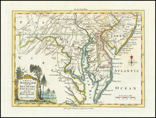
Stock# 100492
Description
Nice example of Carey's map of Maryland, from Carey's American Pocket Atlas, first issued in 1796.
A highly detailed map, which includes towns, roads, rivers, mountains, and many other details.
States of the Map
The map is known in 4 states:
- State 1 (1796): No roads
- State 2 (1801): Boundary of the District of Columbia added. New place names, including Toney, N. Market, Piscataway, Westminster, Havre de Grace and others added. Roads added.
- State 3: (1805): Title of inset altered, removing the F. in "F. Cumberland". New place names include Sharpsburg, Hob Town, Brookville, Allen, Abingdon,k Benton, Hunting and Fderalsburg, among others. New roads added.
- State 4: (1813): S. Branch added in Pennsylvania. Antietam, Dist. of Columbia, Hunting T, Octraro, Greensburg and Bathburg.
Condition Description
Engraving on late 18th or early 19th century wove paper. Excellent tone and structural stability.
![[Jefferson's Notes on the State of Virginia] Observations sur la Virginie [with the map:] A Map of the country between Albemarle Sound, and Lake Erie, comprehending the whole of Virginia, Maryland, Delaware, and Pensylvania, with parts of several other of the United States of America. Engraved for the Notes on Virginia.](https://storage.googleapis.com/raremaps/img/small/51828.jpg)