|
||

|

|
|

|
Names the Sea of Korea
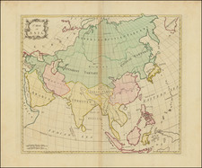
Herman Moll's 1729 map, "Asia," stands as a compelling artifact from the early 18th century, offering a detailed, albeit Eurocentric, perspective of the vast Asian continent as understood by one of London's leading mapmakers of the time.
The map's depiction of geographic regions and boundaries reflects the Western knowledge of the day, a time when cartography was an evolving science, and global exploration was uncovering new lands and cultures. The map delineates Tibet as a region separate from China, suggesting Moll's understanding of the unique cultural and political landscape of these areas.
One notable feature of Moll's map is the depiction of "Iesso Land," a term often used in old maps to refer to the islands north of Japan, represented here as connected to the Asian mainland. This portrayal reveals the incomplete and sometimes inaccurate knowledge of East Asia's geography that characterized European maps of the period. Similarly, the "Sea of Corea" (the Sea of Japan) is identified by its less common name, reflecting the fluid nature of toponyms in a time of increasing global contact.
In the southern region of the map, the partial representation of "New Holland" and "Carpentaria" — early names for parts of Australia — further emphasizes the expanding horizons of the 18th-century European world. These areas, still largely unknown and unexplored by Europeans, are seen only in fragments, hinting at the vast stretches of land and sea that remained to be charted.
Moll's 1729 map of Asia is more than just a geographic illustration; it is a reflection of the historical context in which it was created. The map offers a window into the evolving European understanding of the world during a period of significant global exploration and discovery.
Herman Moll (c. 1654-1732) was one of the most important London mapmakers in the first half of the eighteenth century. Moll was probably born in Bremen, Germany, around 1654. He moved to London to escape the Scanian Wars. His earliest work was as an engraver for Moses Pitt on the production of the English Atlas, a failed work which landed Pitt in debtor's prison. Moll also engraved for Sir Jonas Moore, Grenville Collins, John Adair, and the Seller & Price firm. He published his first original maps in the early 1680s and had set up his own shop by the 1690s.
Moll's work quickly helped him become a member of a group which congregated at Jonathan's Coffee House at Number 20 Exchange Alley, Cornhill, where speculators met to trade stock. Moll's circle included the scientist Robert Hooke, the archaeologist William Stuckley, the authors Jonathan Swift and Daniel Defoe, and the intellectually-gifted pirates William Dampier, Woodes Rogers and William Hacke. From these contacts, Moll gained a great deal of privileged information that was included in his maps.
Over the course of his career, he published dozens of geographies, atlases, and histories, not to mention numerous sheet maps. His most famous works are Atlas Geographus, a monthly magazine that ran from 1708 to 1717, and The World Described (1715-54). He also frequently made maps for books, including those of Dampier’s publications and Swift’s Gulliver’s Travels. Moll died in 1732. It is likely that his plates passed to another contemporary, Thomas Bowles, after this death.
![[ Ancient World ] Christianographie](https://storage.googleapis.com/raremaps/img/small/80305.jpg)
![Asia [with Australia]](https://storage.googleapis.com/raremaps/img/small/72516.jpg)