|
||

|

|
|

|
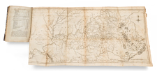
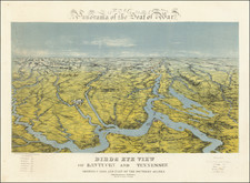
The Largest Map of Kentucky and Tennessee Ever Made
This monumental 1863 military map of Kentucky and Tennessee, drawn by Charles E. Swann, was developed by the Office of the Chief Engineer of the Department of the Ohio, for use by military officers in the midst of the American Civil War.
Prepared under the command of Major Generals Don Carlos Buell, H. G. Wright, and Ambrose E. Burnside, the map is the work of three of the most important mid-19th Century American mapmakers, and Lieutenant Colonel James H. Simpson Major Lorenzo Sitgreaves and Captain Nathaniel Michler, each of which had already established themselves in the Surveying of the American West. Over a period of two years, these accomplished topographical engineers worked to assemble what has been described as the largest and (at the time) most accurate map of the two states ever created. To this day, it remains perhaps the largest map of its kind for Kentucky & Tennessee.
The map is a remarkable compilation of the best available printed and manuscript sources, and includes a list of roughly 20 published and unpublished maps and surveys, including Edmund J. Lee's 1856 New Map of the State of Kentucky, a number of surveys conducted by S.S. Lyons for the State of Kentucky, and numerous surveys conducted by the U.S. Army Corps of Topographical Engineers in 1862 and 1863.
Since there are no county boundaries shown, forts are located at random based on best military information available or else misplaced as a military secrecy measure. The map provides a granular accounting of the infrastructure of the region, including:
- Railroads and Proposed Railroads
- Improved Turnpikes, Stage Roads and Common Roads
- Coal Fields
- Salt Works, Iron Works, Mills & Forges
- Post offices
Produced in Cincinnati, Ohio, in 1863 by Ehrngott, Forbriger & Company. The first issue was printed for the Army Corps of Engineers and had manuscript inscriptions by Lieutenant Colonel Simpson and was only issued only to the most senior commanders for their use in the field. A second state of the map was published in Cincinnati by the army in its own lithography plant and distributed to military officers with lower ranks.
The second issue of the map includes a printed signature, rank and department for Simpson.
The two can be distinguished by the small changes to the imprint at the bottom left with one state having the name Ehrgott, Forbriger & Co. in a small arc (see the Library of Congress example), while the other state has the name and address unchanged, but completely re-engraved, with the name in a straight line (see the David Rumsey example).
Army of the Ohio
The Army of the Ohio, established in 1861, was a significant Union force in the operations throughout Kentucky, Tennessee, and parts of Virginia. Its role and strategic maneuvers in these regions were instrumental in shaping the early and middle phases of the war in the Western Theater.
Formed in November 1861 and named for the Ohio River, the Army was instrumental in the actions in the Western Theater. Under its first commander, Major General Don Carlos Buell, it was tasked with securing Kentucky for the Union. One of the most notable engagements of the Army of the Ohio was the Battle of Shiloh in April 1862. Although the battle was primarily fought by the Army of the Tennessee under Ulysses S. Grant, Buell's forces arrived to reinforce Grant's army on the second day, playing a crucial role in turning the tide against the Confederates. Following Shiloh, the Army of the Ohio was involved in the pursuit of Confederate forces in Tennessee and later, the Kentucky Campaign against Confederate General Braxton Bragg.
After Buell, the command of the Army of the Ohio was handed to Major General Ambrose Burnside in 1862. Under his command, the Army of the Ohio was involved in operations in Eastern Tennessee and Virginia, including the Knoxville Campaign, which was instrumental in securing Union control over much of Tennessee.
The Army of the Ohio was not just a fighting force but also played a significant role in keeping these border states under Union control, thereby denying the Confederacy the resources and support it might have garnered from them. Furthermore, the army's movements in Tennessee helped to destabilize Confederate control in the region, opening the way for further Union advances into the Deep South.
Rarity
The map is rare on the market. This is the first example to appear on the market in nearly 20 years.
James Hervey Simpson (1813–1883) was a distinguished officer in the U.S. Army and an influential member of the United States Corps of Topographical Engineers.
Early Life and Military Beginnings Born on March 9, 1813, in New Brunswick, New Jersey, Simpson was the son of John Simpson and Mary Brunson. His military career began with his graduation from the United States Military Academy in 1832, leading to his initial assignment with the 3rd U.S. Artillery. Simpson's early service included participation in the Second Seminole War, during which he was promoted to first lieutenant in 1837.
Topographical Engineers In 1838, Simpson transitioned to the U.S. Army's Topographical Engineers, a distinct department focusing on mapping and construction projects. He first assisted Cpt. W. G. Williams with harbor construction on Lake Erie and later worked on road construction in Florida and lake surveys in Wisconsin and Ohio. By 1845, he was overseeing the harbor of Erie, demonstrating his growing expertise in topographical engineering.
New Mexico Expedition, 1849 Simpson’s notable westward journey commenced in 1849 under Colonel John James Abert. He surveyed a road from Fort Smith, Arkansas to Santa Fe, New Mexico, and participated in a punitive raid against the Navajo. Simpson's work included collaboration with artists Edward and Richard Kern, resulting in valuable sketches and artwork from the expedition. His successful endeavors in New Mexico led to his appointment as the Chief Topographical Engineer for the Ninth Military Department in Santa Fe.
Other Duties and Utah Expedition Simpson continued his distinguished service by surveying and improving roads in Minnesota in 1851 and was promoted to captain in 1853. His transfer to Florida saw him overseeing survey work for the United States Coast Survey. The Utah Expedition of 1858-59 was a significant chapter in his career. Tasked with mapping routes during the Utah War, Simpson surveyed a wagon road between Camp Floyd and Fort Bridger and conducted reconnaissance into the Great Salt Lake Desert. His expedition in 1859, which included photographer Samuel C. Mills, was crucial for mail, freight, and passenger transportation and laid the groundwork for the Transcontinental Telegraph.
Civil War Service During the Civil War, Simpson served as colonel of the 4th New Jersey Volunteer Infantry, was captured at the Battle of Gaines's Mill, but was later paroled. He resigned his volunteer commission to return as a major in the Corps of Topographical Engineers, where he contributed to the defenses of Cincinnati, Ohio. His wartime service earned him the brevet rank of brigadier general.
Later Career and Legacy In his later years, Simpson served as chief engineer of the Interior Department and oversaw the construction of the Transcontinental Railroad. He retired to St. Paul, Minnesota, in 1880 and passed away there on March 2, 1883. His name endures in geographical features such as the Simpson Park Mountains in Nevada, the Simpson Mountains in Utah, and the Simpson Springs Pony Express Station, all of which commemorate his significant contributions to American topographical engineering and exploration.
Nathaniel Michler, born on September 13, 1827, in Easton, Pennsylvania, was a distinguished army officer and geographer who left an indelible mark on the topographical and engineering studies of the United States. His journey began at Lafayette College and continued to the United States Military Academy at West Point, where he graduated seventh in his class in 1848.
As a brevetted second lieutenant of the Topographical Engineers, he was assigned to Corpus Christi, Texas. There, Michler honed his skills in surveying and military tactics, particularly through his reconnaissance between Corpus Christi and Uvalde, which became a model of geographic exploration upon its publication in 1849.
Michler's expertise in topographical studies led him to work on the Mexican boundary survey from 1851 to 1857, contributing to William H. Emory's influential boundary report. His career progressed with promotions to second lieutenant in 1854 and first lieutenant in 1856. Between 1857 and 1860, Michler undertook a pivotal role as chief topographical engineer in the survey for a canal route across the Isthmus of Darien, modern-day Panama.
His service extended to the Civil War, where as captain, he was integral to the efforts of the armies of the Ohio and Cumberland from 1861 to 1863. His exemplary work led to his transfer to the Army of the Potomac, where he resurveyed Harper's Ferry and was involved in key battles, earning him the ranks of major and eventually brevetted ranks of lieutenant colonel, colonel, and brigadier general for his distinguished service.
Post-war, Michler's skills were sought in various civilian projects, including selecting a site for a presidential mansion in Washington in 1866, contributing to the design of a new War Department building, and managing public buildings and grounds in the District of Columbia. His engineering prowess also led him to oversee a myriad of projects ranging from surveying the Potomac River to supervising river and harbor improvements across several states.
Michler's personal life saw him married twice, first to Fannie Kirkland and, after her death, to Sallie A. Hollingsworth. His life's journey ended on July 17, 1881, when he succumbed to Bright's disease in Saratoga Springs, New York. Nathaniel Michler's contributions to military engineering and geographic surveys had a lasting impact, reflecting a life dedicated to the advancement of America's infrastructure and military fortifications.
Lorenzo I. Sitgreaves, born on March 15, 1810, in Easton, Pennsylvania, was a notable U.S. Army officer and a key member of the Corps of Topographical Engineers. His mother was Mary (née Kemper), whose father, Daniel Kemper, was a colonel in the American Revolutionary War. Sitgreaves graduated from the United States Military Academy in West Point, New York, in 1832, ranking 25th in his class. He began his military career as a Brevet 2nd Lieutenant in the 1st Regiment of Artillery.
Early Military Career Sitgreaves' early military service included the Black Hawk Expedition of 1832 and assignments in various garrisons. He was promoted to Second Lieutenant in 1833 but resigned his commission in 1836 to pursue civil engineering.
Return to Military Service In 1838, he reenlisted as a 2nd Lieutenant in the Corps of Topographical Engineers. His work included road construction in Wisconsin, a survey of Sault Ste. Marie, and work on the U.S.-Texas border, promoting him to 1st Lieutenant in 1840.
Mexican-American War During the Mexican-American War, Sitgreaves participated in General John E. Wool's march from San Antonio to Chihuahua and fought in the Battle of Buena Vista. His bravery earned him a promotion to Brevet Captain in 1847. Post-war, he led the Boundary Survey of the Creek Indian Territory and resumed his duties at the Topographical Bureau in Washington, D.C.
Sitgreaves Expedition, 1851 In 1851, Sitgreaves embarked on an expedition down the Zuni and Colorado rivers, which was the first systematic survey of the area between Zuñi Pueblo and the Colorado River. The goal was to find a route to California. The expedition, completed between September and November 1851, resulted in a significant report published in 1853. Following this, he was promoted to captain.
Personal Life Sitgreaves married Lucy Ann Jesup, daughter of Thomas S. Jesup, in 1854, and they had two daughters, Mary Jesup and Lucy.
Later Career His later career included serving as a Light-House Inspector in Detroit and as a Light-House Engineer in Baltimore. He took a sick leave in 1859 and returned to service during the Civil War as a Mustering Officer and Superintendent of Volunteer Recruiting Service. He was promoted to Major in 1863 and Lieutenant-Colonel in 1864.
Retirement and Death After retiring in 1866 due to health issues, Sitgreaves was involved in settling Ohio and Indiana war claims. He passed away on May 14, 1888, in Washington, D.C., and was laid to rest at Oak Hill Cemetery. Sitgreaves' legacy is defined by his significant contributions to topographical engineering and his distinguished military service.
![(Southern Travel Journal) [Manuscript travel journal to Mobile, Alabama by Andrew Clark, Jr. of Methuen, Massachusetts, also by horseback through Kentucky and Tennessee and up the Mississippi north to Pittsburgh]](https://storage.googleapis.com/raremaps/img/small/93034.jpg)