


|
||

|

|
|

|
Quite Possibly The First Printed Map of South Omaha, Nebraska
Unrecorded map of the recently formed City of South Omaha, during its initial boom period, following the establishment of the city as a major stockyard and meat packing center in the late 1880s.
The present map is perhaps the earliest printed map of South Omaha, Nebraska. Incorporated in 1886, by 1890, the booming stockyard and meat packing industries had seen the town of South Omaha grow to 8,000.
The 1893 map, crafted by City Engineer W.S. King for the South Omaha Land Company, illustrates a tightly packed residential area primarily housing immigrant communities, situated amidst sprawling railway lines and substantial meatpacking plants. Notable industry giants such as Swift & Co., G.H. Hammond, Omaha Packing Co., and Cudahy Packing Co. (previously known as Armour) are prominently marked.
Before the Union Stock Yards were established in 1883, the land that would become South Omaha was mostly undeveloped farmland. The area was profoundly changed when Wyoming cattle rancher Alexander Hamilton Swan decided to establish a stockyards operation to the south of the the city of Omaha. Swan recruited Leverett Anderson and Cornelius Schaller from Omaha to help acquire land for his venture. The land purchasing began with John Kenelly's 280 acres in 1883. Within a span of four months, Swan's land syndicate had amassed a total of 1,875 acres through additional purchases, including significant parcels from Fred Drexel at 25th and N Streets, and John Begley at 33rd and F Streets, for a total investment of $327,000.
After initial Scottish investors withdrew, Swan organized a local syndicate to support the Union Stockyards, compensating for the loss by selling his Swan Land and Cattle Company to them for $2.550 million. However, Swan's aggressive business strategies and losses due to severe winter storms led to his financial downfall later in the decade.
The stockyards commenced operations in August 1884, with Drexel’s former 10-room residence serving as the inaugural Livestock Exchange building. This makeshift facility featured the office in the kitchen, the vault in the pantry, spaces for commission men and a barber shop on the second floor, and a "refreshment parlor" in the basement, symbolizing the humble beginnings of what would become a significant industry.
The South Omaha plate was registered on July 18, 1884. Between 1885 and 1887 four major meat packers—G. H. Hammond (1885), Fowler Brothers (1886), Armour-Cudahy and Swift (both 1887)—established major plants adjacent to the stockyards.
Incorporated as a city in 1886, South Omaha was home to 1,500 people. By 1890, the city had grown to 8,000 people. The rapid expansion of these industries earned South Omaha the nickname 'The Magic City' by the end of the 1880s.
At the time the map was created, the Omaha Motor Railway had not yet been laid out along Bellevue (24th Street), which was destined to become the city's bustling commercial hub, now recognized on the National Register of Historic Places.
South Omaha continued to grow until it annexation by the city of Omaha in 1915.
South Omaha Land Company
The South Omaha Land Company was established in South Omaha, Nebraska, in 1887 with influential founders, including notable figure William A. Paxton. The company's formation was closely tied to the development of the Union Stock Yards Company of Omaha, which purchased 156.5 acres from the South Omaha Land Company for $100,000, intending to use the land as a transfer station for livestock en route to the larger markets in Chicago.
One of the company's notable developments was Syndicate Park in 1887. The company invested approximately $30,000 in the park, hiring landscape architects to improve the area. However, by 1892, the South Omaha Land Company erected a seven-foot fence around Syndicate Park, restricting public access. This led to disputes with local residents, resulting in the company selling parts of the park for residential development while agreeing to keep a portion open for public use. Following the annexation of South Omaha by the City of Omaha in 1917, this public area became known as Spring Lake Park.
Rarity
The map is unrecorded.
Prior to 1900, the only printed map to include South Omaha in the map title was George Gibson's Map of Omaha and South Omaha: with all additions thereto, published in Omaha in 1887.
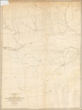
![Military Map of Nebraska and Dakota by Lieut. G.K. Warren . . . [Second state]](https://storage.googleapis.com/raremaps/img/small/95390.jpg)
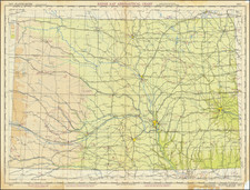
![Rand, McNally & Co's Nebraska [Rand, McNally & Co's Indexed Township and County Pocket Map and Shippers' Guide of Nebraska]](https://storage.googleapis.com/raremaps/img/small/85065.jpg)