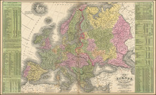
|
||

|

|
|

|
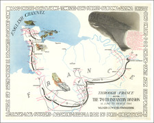
Fascinating pictorial route map from World War II, specifically detailing the journey of the 29th Infantry Division from its training in 1941 until January 1945, along with some fascinating historical vignettes, dating back to the American Revolution.
Created by an anonymous artist in 1945, the map illustrates the division's movements from the United States to England, its time in England, then across the English Channel to France on D-Day, through Europe to Germany, and finally its role in Operation Grenade up to November 1944, which would end with the crossing of the Roer river between Roermond and Düren by the U.S. Ninth Army, commanded by Lieutenant General William Hood Simpson in February, 1945, the month after the publication of this map.
The story begins with the federalization of the 29th on February 3, 1941, and unfolds through a series of vignettes and captions that sketch a brief history of the division, including its origin and its engagement in the Civil War—aptly nicknamed 'The Blue and Gray'. The visual narrative covers the division’s journey from New Jersey to England aboard the Queen Mary in October 1942, training exercises in England in 1943, the pivotal D-Day landing in Normandy on June 6, 1944, and subsequent military operations including the liberation of St. Lo and Vire, the battle for Brest, and the push eastwards through Belgium and the Netherlands.
The vignettes provide a stark, sometimes sardonic window into the soldier's life during the war. Initial vignettes depict soldiers in more relaxed postures, lounging on a Florida beach before shifting to the grim realities of training exercises, the D-Day landing, and the ensuing battles across France. The imagery does not shy away from the harrowing aspects of war, depicting wounded and fallen comrades. In one vivid scene, a soldier is shown storming the beach in Normandy, capturing the intense atmosphere of frontline combat. The map also portrays the division's interactions with the locals, as seen in illustrations of French women offering wine to American soldiers, and moments of levity amidst the conflict.
At the bottom right is a statistical overview of the activities of the 29th and its awards.