|
||

|

|
|

|
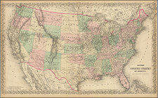
An attractive and detailed map of the United States & Canada, extending nearly to the Rocky Mountains. Texas is shown as a Republic. The region west of the Missouri River is dominated by the Mandan, Osage and Ozark Districts, with a small region called Territoire Des Indiens Du Nord Du Mexique. Massive Iowa extends to Canada. Oversized Nord-Oest Territory ou Ouisconsin. Missouri is misshappen. The map delineates a number of other Indian Regions in Georgia, Alabama, Misssissippi, and other parts. Many forts and Indian Tribes located, along with roads. Insets of Florida and Newfoundland. Several interesting annotations in the body of the map. The second edition of the map, following the first edition of 1837. This is the first edition to show Texas as a Republic.
Andre Hubert Brué was a French geographer and cartographer. Born in Paris, he served in the French Navy, joining the Baudin expedition to the Pacific (1800-1804). After his sea service, Brué applied his navigation and charting skills to creating finely-crafted maps, which were renowned for their crisp engraving and accuracy. He drew directly on the copper of the plate, creating what he called encyprotypes. He is best known for the Atlas universal de géographie physique, politique, ancienne et moderne.
![[French & Indian War] Carte Des Possessions Francoises et Angloises dans le Canada et Partie de la Louisiane . . . 1756](https://storage.googleapis.com/raremaps/img/small/94026.jpg)