This item has been sold, but you can enter your email address to be notified if another example becomes available.


|
||

|

|
|

|
Stock# 0096bm
Description
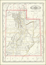
Fine topographical map of Utah Territory, published for the US Geological Survey, under the direction of J.W. Powell.
This is one of the best maps of Utah from the period. The map shows railroads, wagon road, telegraph lines, etc.
Includes explanation, and note:
This map has been constructed from atlas sheets of the U.S. Geographical and Geological Survey of the Rocky Mountain region with additional material taken from the maps of the U.S. Geographical Explorations and surveys west of the 100th meridian, Lieut. Geo. M. Wheeler, Corps of Engineers, in charge ; the U.S. Geological Exploration of the 40th parallel, Clarence King, U.S. Geologist in charge; and the U.S. Geological and Geographical Survey of the Territories, F.V. Hayden, in charge.
Condition Description
Minor toning at folds
![[ Hungarian Traveler In the California and the West with a Comanche and Wichita to Hungarian vocabulary ] Levelei Éjszakamerikából -- Tizenkét eredeti rajzok után készült kő- és egynéhány fametszettel. Közli Prépost István (Letters from North America)](https://storage.googleapis.com/raremaps/img/small/98502.jpg)

![History of the Expedition under the Command of Captains Lewis and Clark, to the Sources of the Missouri Thence across the Rocky Mountains and Down the River Columbia to the Pacific Ocean, Performed During the Years 1804-5-6 [with map:] Map of Lewis and Clark's Track, Across the Western Portion of North America from the Mississippi to the Pacific Ocean](https://storage.googleapis.com/raremaps/img/small/92506.jpg)