|
||

|

|
|

|
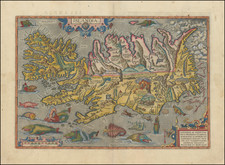
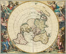
Early Map of the Polar Regions, Showing The Discoveries of Barentsz and Henry Hudson.
First state of a very early and scarce map of the North Pole and Arctic regions showing recent discoveries, including the voyage of Jan Willem Barentsz on his quest to find a Northeast Passage to the East Indies.
Among the more noteworthy features of the map is the mythical island of Frisland and and early reference to Fretum Anian (the Straits of Anian).
To the north of the east coat of Greenland, the words, "Glacies ab Hhussono detecta ann. 1608" appear, which translates to "Ice found by H. Hudson in the year 1608," a reference to Henry Hudson's voyage of 1607.
Another interesting note is the location of Hugo Willoughbes lant is shown. During his 1553 voyage across the Barents Sea, English explorer Hugh Willoughby thought he saw islands to the north. Based on his description, these islands were subsequently depicted and named "Willoughby's Land" and "Macsinof Island" on maps published by Petrus Plancius in 1592 and 1594 (although he was doubtful of their existence). Gerard Mercator included them on his 1595 map. Willem Barentsz found no sign of Willoughby's discoveries and omitted them from his map published in 1599, but they continued to appear on Arctic maps published by Jan Janssonius and Willem Blaeu at least into the 1640s.
Jodocus Hondius the Elder (1563-1612), or Joost de Hondt, was one of the most prominent geographers and engravers of his time. His work did much to establish Amsterdam as the center of cartographic publishing in the seventeenth century. Born in Wakken but raised in Ghent, the young Jodocus worked as an engraver, instrument maker, and globe maker.
Hondius moved to London in 1584, fleeing religious persecution in Flanders. There, he worked for Richard Hakluyt and Edward Wright, among others. Hondius also engraved the globe gores for Emery Molyneux’s pair of globes in 1592; Wright plotted the coastlines. His engraving and nautical painting skills introduced him to an elite group of geographic knowledge seekers and producers, including the navigators Drake, Thomas Cavendish, and Walter Raleigh, as well as engravers like Theodor De Bry and Augustine Ryther. This network gave Hondius access to manuscript charts and descriptions which he then translated into engraved maps.
In 1593 Hondius returned to Amsterdam, where he lived for the rest of his life. Hondius worked in partnership with Cornelis Claesz, a publisher, and maintained his ties to contacts in Europe and England. For example, from 1605 to 1610, Hondius engraved the plates for John Speed’s Theatre of the Empire of Great Britaine.
One of Hondius’ most successful commercial ventures was the reprinting of Mercator’s atlas. When he acquired the Mercator plates, he added 36 maps, many engraved by him, and released the atlas under Mercator’s name, helping to solidify Mercator’s reputation posthumously. Hondius died in 1612, at only 48 years of age, after which time his son of the same name and another son, Henricus, took over the business, including the reissuing of the Mercator atlas. After 1633, Hondius the Elder’s son-in-law, Johannes Janssonius, was also listed as a co-publisher for the atlas.