Search
Gabriel Walser he began his theology studies in Basel in 1712, and, after study visits in Marburg, Tübingen, Jena, and Halle, he completed his examination there in 1717. He became a member of the Appenzell Synod. In 1718, he married Maria Elisabeth Zollikofer, who hailed from a noble St. Gallen family and was the daughter of Ruprecht Zollikofer. In 1721, he was elected as the pastor of Speicher, where he served from 1721 to 1745. In the land trade, he took the side of the defeated Lindens and was thus fined in 1732. In 1745, he took up the pastoral position in Berneck, which he held until his death.
In addition to his duties as a pastor, Gabriel Walser wrote the "Old and New Appenzeller Writing Calendar" for the years 1738 to 1745, a collection with easy-to-understand scientific, historical, and narrative content.
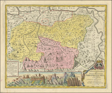
His main work was the "Neue Appenzeller-Chronick or Description of the Canton of Appenzell of the Inner and Outer Rooden", self-published in 1740. This history of the Canton since Roman times also included geographic descriptions, including a map of Appenzell. It contained an appendix with various documents from the years 1378 to 1667 and an official directory. Walser's chronicle is considered an extension and continuation of the Appenzell Chronicle of the pastor Bartholomäus Bischofberger from Trogen, which goes up to the year 1682. The more valuable, regional part of the chronicle is based on his observations. The historical part connects to Bartholomäus Bischofberger's work and supplements it up to 1732. His continuation for the years 1732 to 1772 was only published in 1829.
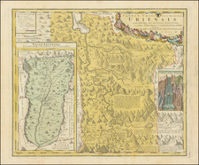
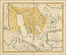
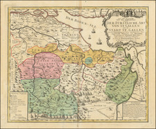
For the Augsburg publisher Matthaeus Seutter, Walser created maps of the cantons Lucerne, Uri, Schwyz, Glarus, and Appenzell as well as Graubünden, after numerous trips through eastern and central Switzerland. For the "Atlas Novus Reipublicae Helveticae", published in Nuremberg in 1769, he created,15 maps covering 18 cantons covering the 18 cantons of the Old Confederacy (excluding Schaffhausen) and the territories of St. Gallen, Graubünden, and Wallis, based on maps by Johann Jakob Scheuchzer, Hans Konrad Gyger, and others,from 1763 to 1768. Walser did not carry out any surveys for this. However, his maps represent a slight qualitative improvement compared to Scheuchzer's maps. In 1770, Walser's "Swiss Geography with the Sights in the Alps and High Mountains" was published in Zurich. This is an explanation of the atlas.