|
||

|

|
|

|
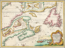
Acadia, Isle St. John, and Isle Royale During The Acadian Expulsion Period
Detailed map of the region, published during the Acadian Expulsion and at the outset of the Seven Years War (French & Indian War).
Throughout the 18th century, the regions of Acadia (now the Maritime provinces of Canada), Isle St. John (present-day Prince Edward Island), and Isle Royale (Cape Breton Island) were areas of strategic importance in North America, caught in the web of imperial rivalries between France and Britain. These territories were not just geopolitical pawns; they were also homes to rich cultures, notably the Acadians.
In the early 18th century, the French established fortified settlements in Acadia and on Isle Royale, with the most significant being Louisbourg on Isle Royale. Fort Louisbourg was a crucial French stronghold and commercial hub, one of the busiest ports in North America, acting as a gateway to the St. Lawrence River and the Canadian interior.
The beginning of the century saw Acadia as a battleground during Queen Anne's War, the North American theater of the War of the Spanish Succession. The Treaty of Utrecht in 1713 concluded this conflict, ceding large portions of Acadia to the British, though boundaries remained ambiguously defined.
Arguably the most significant event in 18th-century Acadia was the expulsion of the Acadians starting in 1755. Amid the French and Indian War (the North American front of the Seven Years' War), British concerns over Acadian loyalty led to the brutal decision to deport them. Thousands were forcibly removed, with many resettling in Louisiana, becoming the ancestors of the Cajun people.
Isle Royale's Fort Louisbourg, once thought impregnable, fell to British forces in 1758 after a fierce siege. Its capture was a pivotal moment in the Seven Years' War, paving the way for the British to launch a successful campaign against Quebec.
The Seven Years' War culminated in the Treaty of Paris in 1763. This treaty had profound implications for the territories in question. France ceded Isle Royale and Isle St. John to the British, marking the end of the French colonial era in the Maritimes.
Following the treaty and the Acadian expulsion, these territories saw an influx of British settlers, particularly on Isle St. John. The fabric of the region began to change, with English laws, language, and customs gaining prominence.
Jacques-Nicolas Bellin (1703-1772) was among the most important mapmakers of the eighteenth century. In 1721, at only the age of 18, he was appointed Hydrographer to the French Navy. In August 1741, he became the first Ingénieur de la Marine of the Dépôt des cartes et plans de la Marine (the French Hydrographic Office) and was named Official Hydrographer of the French King.
During his term as Official Hydrographer, the Dépôt was the one of the most active centers for the production of sea charts and maps in Europe. Their output included a folio-format sea atlas of France, the Neptune Francois. He also produced a number of sea atlases of the world, including the Atlas Maritime and the Hydrographie Francaise. These gained fame and distinction all over Europe and were republished throughout the eighteenth and even in the nineteenth century.
Bellin also produced smaller format maps such as the 1764 Petit Atlas Maritime, containing 580 finely-detailed charts. He also contributed a number of maps for the 15-volume Histoire Generale des Voyages of Antoine François Prévost.
Bellin set a very high standard of workmanship and accuracy, cementing France's leading role in European cartography and geography during this period. Many of his maps were copied by other mapmakers across the continent.
![[ New England / Northeast / Canada ] Tierra Nueva](https://storage.googleapis.com/raremaps/img/small/86737.jpg)