


|
||

|

|
|

|
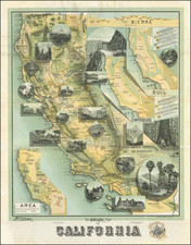
California by Rand McNally & Co., published in Chicago in 1888, offers an intriguing snapshot of the state at the close of the 19th century, notably marking an early appearance of Orange County on the cartographic record. The detail captured spans from the intricate railway lines connecting various towns to the grand geographical expanse of California, topped by a distinct inset map focusing on the Bay Area.
The latter years of the 19th century heralded a transformative phase in California's history. The Gold Rush of the mid-century had set in motion an unstoppable tide of migration, leading to significant urban and infrastructural developments. The mapping of Orange County, despite its chronological anomaly with the map's dating, symbolizes this evolving geopolitical landscape. The formation of Orange County in March 1889 stands as a testament to the growth and administrative restructuring taking place throughout the state.
The presentation of the railway lines is especially telling of the era. The late 19th century marked the zenith of railroad expansion in the United States, fundamentally altering commerce, communication, and daily life. In California, these lines not only connected towns within the state but also served as vital arteries linking it to the rest of the nation, acting as a conduit for goods, people, and ideas.
Furthermore, the inclusion of a sizeable inset map of the Bay Area underscores the region's burgeoning significance. As one of the principal hubs of commerce, migration, and innovation, the Bay Area's detailed representation resonates with its rising stature in both the state and the nation. It encapsulates the convergence of natural beauty, burgeoning urban centers, and economic promise that would pave the way for the region's 20th-century ascendance.
Rand McNally & Co. is a large American map and navigation company best known for its annual atlases. The company got its start in 1856, when William Rand opened a print shop in Chicago. He was joined in 1858 by a new employee, Andrew McNally. Together, the men established their namesake company in 1868. Originally, the company was intended to print the tickets and timetables for the trains running to and through Chicago; their first railway guide was published in 1869.
By 1870, they had shifted from just printing to publishing directories, travel guides, and newspapers. Their first map appeared in 1872 in a railway guide. The map was produced using a new wax engraving method, a cheaper process that gave the company an edge.
By 1880 Rand McNally had entered the education market with globes, wall maps, and geography texts for students. In 1923, Rand McNally published the first Goode’s World Atlas, named after its editor, Dr. J. Paul Goode. For generations afterward, this would be the standard classroom atlas.
In 1899, William Rand left the company, but McNally and his family remained, controlling the company for over a century. In 1904, they published their first road map intended for automobiles and by 1907 were publishing Photo-Auto Guides, which combined photography and mapping to help drivers. In 1924, they produced the Auto Chum, a precursor to their famous road atlases. Rand McNally would remain the leader in road maps and atlases throughout the twentieth century.
In 1937, Rand McNally opened its first store in New York City. Ever on the frontier of technology, Rand McNally pioneered the scribing process for printing tickets in 1958 and printed their first full-color road atlas in 1960. Arthur Robinson developed his now-famous projection of Rand McNally in 1969. By the 1980s, the company was exploring digital reproduction and digital databases of maps for truckers. In the 1990s, they lead the charge to develop trip-planning software and websites. Today, most of its products are available online or in a digital format, including maps for tablets and phones.
![[ Lake County Rancho ] Map of the Guenoc County Rancho Finally Confirmed To A.A. Ritchie & P.S. Forbes, Surveyed under the Direction of the U.S. Surveyor General By Wm. Denton Deputy Surveyor. June 1857.](https://storage.googleapis.com/raremaps/img/small/102630.jpg)
![(California Oil Fields) [15 original photographs of Tupman Lease oil derricks and oil facilities at Taft, Kern County, California]](https://storage.googleapis.com/raremaps/img/small/94701.jpg)
![[First California Wine Making Image] The Vintage In California -- At Work At The Wine Presses](https://storage.googleapis.com/raremaps/img/small/89054.jpg)
![[ Southern California Tourism ] Hunting and Fishing in Southern California on the Santa Fe](https://storage.googleapis.com/raremaps/img/small/101613.jpg)