|
||

|

|
|

|
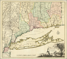
Amsterdam edition of Sanson's seminal map of Canada and the Great Lakes, which would influence the cartography of the region for the next 100 years.
Along with Sanson's folio map issued a year earlier, this map includes many cartographic firsts and changes of great note. The map shows the first appearance of Lake Erie ou du chat, which referenced the panther like qualities of the local Indians. Much improvement in the drainage of the Great Lakes and St Lawrence.
The map draws heavily on the Jesuit explorations to the west and the travels of the French Fur Traders. Greater detail shown in Hudson Bay than in earlier maps. Long Island is introduced and New Amsterdam is correctly placed. The Delaware River's course is greatly improved and the Swedish Colony noted (although by then defeated). New Netherlands is shown extending to Cape Cod.
The classic open Great Lakes from Sanson's North American map are shown in fine detail.
While not recorded by Burden, the map is a variant of Sanson's Le Canada ou Nouvelle France &c, first publshed in 1657.
Nicholas Sanson (1600-1667) is considered the father of French cartography in its golden age from the mid-seventeenth century to the mid-eighteenth. Over the course of his career he produced over 300 maps; they are known for their clean style and extensive research. Sanson was largely responsible for beginning the shift of cartographic production and excellence from Amsterdam to Paris in the later-seventeenth century.
Sanson was born in Abbeville in Picardy. He made his first map at age twenty, a wall map of ancient Gaul. Upon moving to Paris, he gained the attention of Cardinal Richelieu, who made an introduction of Sanson to King Louis XIII. This led to Sanson's tutoring of the king and the granting of the title ingenieur-geographe du roi.
His success can be chalked up to his geographic and research skills, but also to his partnership with Pierre Mariette. Early in his career, Sanson worked primarily with the publisher Melchior Tavernier. Mariette purchased Tavernier’s business in 1644. Sanson worked with Mariette until 1657, when the latter died. Mariette’s son, also Pierre, helped to publish the Cartes générales de toutes les parties du monde (1658), Sanson' atlas and the first French world atlas.

![[Rare First State] Novissima Tabula Regionis Ludovicianae Gallice dictae la Louisiane . . .](https://storage.googleapis.com/raremaps/img/small/72622.jpg)
![[ Bunker Hill ] A Plan of the Action at Bunkers Hill on the 17th of June 1775 between His Majesty's Troops, Under the Command of Major General Howe, and the American Forces . . .](https://storage.googleapis.com/raremaps/img/small/70223.jpg)