|
||

|

|
|

|
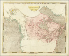
British America by John Tallis, published in London in 1851, offers a detailed and vivid representation of British territories in North America, present-day Canada. Showcasing a rich decorative border, the map is further embellished with intricate vignettes illustrating indigenous scenes, natural elements, and key landmarks such as Montreal. Notably, a notation draws attention to the forts and primary stations of the Hudson's Bay Company, signified by distinct red dots.
The mid-19th century marked a period of intense exploration and documentation of the vast expanses of British America. As colonial interests expanded, maps such as this one by Tallis served as both practical navigational tools and expressions of imperial reach. The inclusion of vignettes, portraying scenes like "Whale Fishing" and "Esquimaux," reveals an effort to capture the diverse cultures and environments of these territories, reflecting the European fascination with the "exotic" and the unknown.
The Fury and Hecla Strait is a narrow channel of water located in the Qikiqtaaluk Region of Nunavut, Canada, separating Baffin Island to the north from the Melville Peninsula to the south. The strait is named after two British ships, the HMS Fury and HMS Hecla. These vessels were part of an 1821-1823 expedition led by Captain William Parry, aimed at discovering the Northwest Passage, a sought-after sea route that would connect the Atlantic and Pacific Oceans.
John Tallis's cartographic works stand out in the annals of map-making, particularly for their ability to combine precise geographical details with a keen aesthetic sense. This map, specifically engraved for R. Montgomery Martin's Illustrated Atlas, is no exception. The meticulous depiction of key landmarks, flora, fauna, and indigenous populations stands as a testament to the cartographer's commitment to both artistry and accuracy.
As a fusion of cartography and art, Tallis's British America stands as a comprehensive testament to a region in transition, caught between indigenous cultures, emerging colonial influences, and the vast, untamed wilderness of the North American continent.
John Tallis (1817-1876) was a British map publisher. Born in the Midlands, Tallis came to London in the 1840s. Tallis began his London career with a series of remarkable London street views. He began a partnership with a Frederick Tallis, possibly his brother, but their collaboration ended in 1849. For the Great Exhibition of 1851, Tallis published the Illustrated World Atlas, one of the last series of decorative world maps ever produced. The maps were engraved by John Rapkin, a skilled artisan. The maps were later reissued by the London Printing & Publishing Company, who left the Tallis imprint intact, thus ensuring his enduring fame. In 1858, he began publication of the popular Illustrated News of the World and National Portrait Gallery of Eminent Personages, selling it in 1861 (it ceased publication in 1863).

![Colton's Map of the United States The Canadas &c. Showing the Railroads, Canals, & Stage Roads With Distances From Place to Place…1856 [Pocket Map]](https://storage.googleapis.com/raremaps/img/small/85342.jpg)

![[ English Plantations in North America ] A New Map of the most Considerable Plantations of the English In America Dedicated to His Highness William Duke of Glocester.](https://storage.googleapis.com/raremaps/img/small/98233.jpg)