|
||

|

|
|

|
Spectacular promotional tract map and birdseye view of the Perrin Colony, located near the town of Fresno, California.
The work provides a fine illustration of the first Perrin Colony, one of the earliest large scale farming colonies near the newly formed City of Fresno, which was incorporated in 1885. The plat map of the Colony is surrounded by vignettes of Fresno County Vineyards and an idealized use of the 20 acre parcels being sold by Edward B. Perrin through his agents, Sharp-Blakely & Thomas, including 10 acres for grapes, 5 acres for orchards, 2.5 acres for Alfalfa and 2.5 acres for the main grounds of the house. The promotional tract below the model farm proclaims:
Ideal 20 Acre Rural Homestead -- The finest tract of Raisin Land ever offered for sale in Fresno County. All Irrigated by the Fresno Canal Company. Deeded Water Right to Every Lot of Land.
For Sale In Twenty Acre Lots -- On Easy Terms
$1500 Buys a Lot -- Quarter down, Balance in One, Two and Three Years, Interest at 8 percent . . .
Below the tract map are additional vignettes of fruits, a map of California and a birdseye view of Fresno City. To the left of the primary image, a large map of the Fresno County area, centered on Fresno City and the Perrin Colony.
The Perrin Colony was the creation of Dr. Edward B. Perrin (born 1839 in Green County, Alabama) of San Francisco, California. Perrin was the son of a wealthy Southern Plantation owner, who graduated from both Medical School and Law School. After service in the Civil War, Perrin moved to California, where he began purchasing land throughout California and Arizona, speculating on the routes of the various railroads, purchasing land from Redding to Los Angeles in large quantities. He also undertook the construction of a number of irrigation canals in the Fresno area. In all, he amassed over 500,000 acres of land in Fresno County and developed 5 different Perrin Colonies, of which this was the first, which was developed in the late 1880s. As noted by Virginia Thickens in Pioeneer Agricultural Colonies of Fresno County, California Historical Society Quarterly, Vol. 25, No. 2 (Jun., 1946), pp. 169-177:
Dr. E. B. Perrin first speculated in Fresno lands in 1868. In anticipation of coming railroad developments, he bought up property also in Shasta, Tehama, Mendocino, Sonoma, Marin, Napa, Alameda, and Los Angeles counties. In Fresno County he acquired more than 130,000 acres, and to provide them with water, he organized the Upper San Joaquin Canal Company in 1876. This enterprise failed because, to use his own words, "they struck financial difficulties and hard rock." Not until he bought the Fresno Canal and Irrigation Company from Church in 1887 did he success fully irrigate his land. The establishment of the Perrin Colonies around Fresno dated from that time. The first colony of 7040 acres lay west of the American Colony; the others, five in number, were north and northwest of the city. The Holland Colony, or Perrin Colony Number Six, was a failure because of hardpan land, which was unfit for cultivation. Had they known
that by blasting out the surface hardpan they would reach tillable subsoil, their fate might have been different. The colony was looked upon as a fraudulent scheme, since the colonists were induced to invest in land which a "pick would not disintegrate and which was impervious to water."
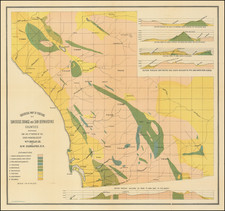
The cadastral map at the left of the image locates the Perrin Colony on the larger Cadastral map, showing the its location relative to Fresno City and a number of other developments, including Pomona Colony, Fruit Vale Estate, Belfast Colony, California Colony, American Colony, Washington Colony, Central Colony, Malaga Colony, Fresno Colony, Nevada Colony, Sierra Park Vineyard Colony, Norris Colony and a host of other smaller colonies, spread between the towns of Fowler, Malaga, Butler, Selma, and Herndon (no longer a town), centered on Fresno City. Other towns appearing include Elkhorn (no longer a town), Reedley, Fortuna (no longer a town), Traver, Kinbsburg, Sanger & Minneola (no longer a town).
The map locates a number of Property owners, including the lands of the Bank of California. Virtually all of the development is between the lines ofthe Southern Pacific Railroad and the San Pablo & Tular Extension Railroad, with the San Francisco and San Joaquin Valley Railroad depicted between the two larger routes.
The map and view are of the utmost rarity. OCLC locates only the example at the Bancroft Library, University of California Berkeley.
![California [early appearance of Orange County!]](https://storage.googleapis.com/raremaps/img/small/96829.jpg)
![[Southern California Views] Delightful Southern California, The Land of Sunshine and Bloom](https://storage.googleapis.com/raremaps/img/small/74862.jpg)