
Search
Troye was a surveyor, cartographer and consulting engineer, who compiled a number of important maps of the Transvaal and its gold fields.
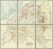
His most important contribution to cartography was Troye's map of the Transvaal or S.A. Republic (1:500 000, on 6 sheets), lithographed in Switzerland and published in six colors in Pretoria. The map was the first topo-cadastral map of the Transvaal and by far the most complete, accurate and attractive map of the territory produced up to that time.
He used farm diagrams and inspectors' records in the surveyor-general's office to map farm boundaries and list farm names, while information was also obtained from F.H. Jeppe's* map of 1889.
Place/Date:
Winterthur, Swizerland / 1896
Size:
64 x 57.5 inches (if joined)
Condition:
VG
Stock#:
87453