Search
Reading Howell (1743–1827) was a distinguished American engineer, surveyor, and landowner, based in Pennsylvania, whose professional life spanned the transformative period from colonial times through the early years of the United States. Renowned for his surveying and cartographic skills, Howell played a pivotal role in the mapping and development of Pennsylvania during the late 18th and early 19th centuries.
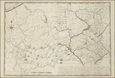
Born into the era preceding the American Revolutionary War, Howell's contributions to surveying began to gain prominence as the newly formed United States embarked on establishing its geographic and civic infrastructures. His work included detailed surveys of major Pennsylvania waterways—the Delaware, Lehigh, and Schuylkill Rivers—which were critical for commerce and transportation in the burgeoning nation.
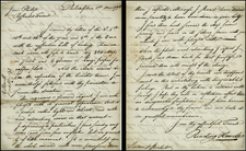
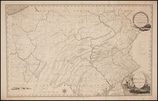
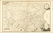
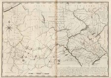
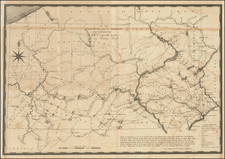
In 1789, recognizing his expertise, the Pennsylvania assembly commissioned Howell to create a comprehensive map of the state for the substantial sum of two hundred pounds. Published in 1792, this map was the first of Pennsylvania to be issued after the American Revolutionary War. It stood out as the most detailed and accurate representation of the state at the time, incorporating extensive cartographic data accumulated by both American and British military surveyors during the war. This map not only served as a vital tool for state planning and development but also as a significant artifact in the cartographic history of the United States.
From 1804 until his death in 1827, Howell held prominent civic roles in Philadelphia, including "Principal City Surveyor" and "City Regulator." In these capacities, he was intimately involved in urban planning and the resolution of land disputes, leaving an indelible mark on the physical and legal landscape of the city. His surveys and maps became authoritative resources, used extensively in legal settings and city planning.
Howell’s legacy is cemented in the annals of American surveying and cartography, with his early works remaining a reference point for historians and cartographers studying the post-revolutionary period. His meticulous records and maps continue to be valued for their historical significance and precision, reflecting the foundational years of American geography and the critical role of surveyors in shaping the nation’s early development.
Archived