Search
Vinzenz Haardt von Hartenthurn was a cartographer and military geographer.
Haardt was born in Iglau (Jihlava, Moravia) on August 13, 1843, and died in Vienna on August 1, 1914. His father was a general major.
Vinzenz finished his studies at the Theresian Military Academy and the Imperial Royal War School in Vienna. He participated in the 1866 campaign in Italy, fought against the insurrection in Cattaro in 1869, and became a captain in the General Staff. By 1872, he was a professor at the Technical Military Academy and from 1877 to 1896, he was the scientific head at Eduard Hölzel. In 1897, he became the head of the 1st department at the Military Geographical Institute, was made a government councilor in 1896, and a ministerial councilor in 1912. He attended numerous international geographical congresses and the international earth map conference in London in 1909 and in Paris in 1913.
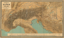
His work focused on cartography and school geography, contributing to atlas and wall maps, and writing explanations for map works. Notably, he worked on the wall map of the Alps and the text for the portable edition of the "Geograph. Charakterbilder" along with Fr. Umlauft. His research on the history of cartography, especially on the cartography of the Balkan Peninsula in the 19th and 20th centuries, the development of cartography in Austria, and the Military Geographical Institute, are of lasting value. He was also the editor of the "Mitteilungen der Geographischen Gesellschaft Wien" in 1884 and 1885.
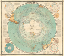
His works include several editions of the Kozenn Atlas, the Geographic Atlas of the Austro-Hungarian Monarchy in 1883, a wall map of the Alps in 1882, an overview map of the ethnographic conditions of Asia in 1887, a South Pole map in 1895, and a hand map of Bosnia and Herzegovina in 1907, among others. He also authored significant writings on the division of the Alps, the development of cartography in Austria, and the military geographical Institute, as well as other contributions to the understanding of military topographical work in Europe and the cartography of the Balkan Peninsula.
Archived