Search
William Emery Merrill was the son of Captain Moses Merrill.
Merrill graduated first in his class from West Point in 1859, demonstrating early on his aptitude for military engineering. Following his graduation, he served as an assistant professor of engineering at West Point from September 1860 to July 1861.
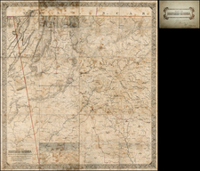
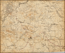
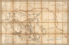
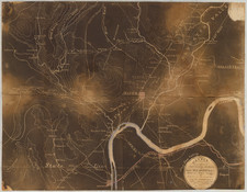
His role as the head of the Topographical Department of the Army of the Cumberland during the Civil War, particularly in providing maps for the Atlanta Campaign, was a hallmark of his military career. Under his leadership, the department was equipped with advanced mapmaking technology, including lithographic and photoprinting equipment. His team's meticulous work in map production, notably the detailed map of northern Georgia for the Atlanta Campaign, was crucial for the Union Army. The maps produced under his direction were not only essential for tactical planning but also for operational maneuvering.
Colonel William E. Merrill, a key figure in the advancement of military cartography during the American Civil War, played a crucial role as the head of the Topographical Department of the Army of the Cumberland. His department's work, particularly in providing maps for the Atlanta Campaign, stands as a testament to the vital role of accurate cartographic information in military operations.
Under Merrill's direction, the Topographical Department was a self-sufficient unit, equipped with a printing press, two lithographic presses, a photographic establishment, facilities for map-mounting, and a team of skilled draughtsmen and assistants. This level of self-reliance was necessary due to the army's distance from Washington, requiring them to have their own comprehensive map production capabilities.
The lithographic presses, a central component of Merrill's operation, were instrumental in producing multiple copies of maps quickly. However, the logistical challenge of transporting these heavy presses required them to be stationed at a central depot near the front lines. To complement this, Merrill's team also utilized a mobile photoprinting device invented by Captain Margedant. This device, comprising a light box with India rubber baths and a supply of chemicals, allowed for the tracing of maps on thin paper laid over a sheet coated with nitrate of silver. Exposed to sunlight, this produced a white map on a black background. Despite its cost and limitation in producing large quantities, this method was vital for issuing updated maps to high-ranking commanders.
The Topographical Department's most significant achievement under Merrill was the creation of an accurate campaign map of northern Georgia. This task involved enlarging the best available map to a scale of an inch to the mile and refining it with information gathered from various sources, including refugees, spies, and prisoners. The meticulousness of this process was underscored by the fact that crucial geographic features, such as Snake Creek Gap, were identified and added to the maps, despite not being present on any previously available printed maps.
In preparation for the Atlanta Campaign, the department faced the challenge of rapidly producing this detailed map. The map, once completed, was divided and distributed among draughtsmen to be traced on thin paper. These sections were then lithographed, producing two hundred copies per set of four sections. The map-mounters then bound these sections into a complete map, which was distributed to commanders before the campaign's commencement. This map, titled "Map of Northern Georgia made under the direction of Capt. W. E. Merrill," was not only printed on paper but also on muslin for the cavalry's convenience, allowing for maps that were durable and easy to clean.
The Topographical Department's work under Merrill's guidance was highly praised, with Thomas B. Van Horne concluding that General Sherman's army was the best supplied with maps of any in the Civil War.
Post-war, Merrill continued his distinguished career in military engineering. In March 1867, he was promoted to the regular rank of major, and by February 1883, he had risen to lieutenant colonel. He served as chief engineer on the staff of General Sherman, then commanding the Military Division of the Missouri, from 1867 to 1870. His post-war period was characterized by significant engineering work for the government, including the construction of the Chanoine wicket movable dam at Davis's Island, near Pittsburgh, one of the most notable engineering works of its kind in America.
His expertise was recognized internationally when he represented the United States Engineering Corps at the International Congress of Engineers in Paris in 1889. Merrill was also an author, contributing to the field with works such as "Iron Truss Bridges for Railroads" (1870) and "Improvement of Non-Tidal Rivers" (1881).
Archived