

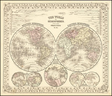
The sixth and final state of De Fer's rare wall map of the world, first published in 1700. The text notes that the map is a reduction of De Fer's 4 sheet wall map of the world, first issued in 1695. De Fer states that this map is the first map to be prepared based upon the astronomical observations of the Royal Academy of Sciences. In fact, it would appear that different sources entirely have been consulted for California, Japan and Australia. Australia is shown as substantially incomplete and still attached to new Guinea. New Zealand appears in partial outline. The conjectural land bridge from Asia to America is still in evidence. The Mississippi River has its confluence with the Gulf of Mexico considerably west of its true course, based upon La Salle's eroneous reports. There are many more place names on this 2 sheet edition of the wall map. The scientific comenatary is quite remarkable and detailed. Engraved by Van Loon Vignettes show thunder, lightening, tempests and tides, volcanoes, etc. Celestial observations are shown at the top. A nice example of this rare two sheet map of the world, given an R rating by Shirley (#600). No example has been offered in a dealer catalogue in the past 10 years. Minor restorations at centerfold, but in all a gorgeous example.
Nicholas de Fer (1646-1720) was the son of a map seller, Antoine de Fer, and grew to be one of the most well-known mapmakers in France in the seventeenth century. He was apprenticed at twelve years old to Louis Spirinx, an engraver. When his father died in 1673, Nicholas helped his mother run the business until 1687, when he became the sole proprietor.
His earliest known work is a map of the Canal of Languedoc in 1669, while some of his earliest engravings are in the revised edition of Methode pour Apprendre Facilement la Geographie (1685). In 1697, he published his first world atlas. Perhaps his most famous map is his wall map of America, published in 1698, with its celebrated beaver scene (engraved by Hendrick van Loon, designed by Nicolas Guerard). After his death in 1720, the business passed to his sons-in-law, Guillaume Danet and Jacques-Francois Benard.
![[Tracking Noah's Descendants] The Countries of The Ancient World Exhibiting The Probable Settlement of the Descendants of Noah . . .](https://storage.googleapis.com/raremaps/img/small/97933.jpg)
![[ Indian Cave and Rock Paintings ] World Primitive Rock Art -- The Conquest of Indian America](https://storage.googleapis.com/raremaps/img/small/93916.jpg)
![(Mississippi Bubble) [Lukewarm Month's Commemoration, due to the recently acquired Golden Age, enchanted in Horse Figs. New Year's Gift.]](https://storage.googleapis.com/raremaps/img/small/94313.jpg)
![[ Map Game Board ] Wallis's New Game, exhibiting a Voyage round the World.](https://storage.googleapis.com/raremaps/img/small/98593.jpg)