
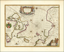

A nice example of Blaeu's signature map of the North Polar Regions, with several wonderful cartouches (we liked them so much we used them to illustrate our website) and decorative coat of arms. Wonderful detail, both real and imaginary, throughout the map. The discoveries of the late 16th and early 17th Centuries are plainly in evidence throughout Hudson's Baffin's and Buttons Bay, along with Davis Straits. Greenland has many bays named. Spitsberg and Nova Zemla are shown, but I not in a complete fashion. 8 compass roses and 4 sailing ships. A nice old color example of this highly sought after map. Minor soiling in upper left corner and in margins, outside image.
Willem Janszoon Blaeu (1571-1638) was a prominent Dutch geographer and publisher. Born the son of a herring merchant, Blaeu chose not fish but mathematics and astronomy for his focus. He studied with the famous Danish astronomer Tycho Brahe, with whom he honed his instrument and globe making skills. Blaeu set up shop in Amsterdam, where he sold instruments and globes, published maps, and edited the works of intellectuals like Descartes and Hugo Grotius. In 1635, he released his atlas, Theatrum Orbis Terrarum, sive, Atlas novus.
Willem died in 1638. He had two sons, Cornelis (1610-1648) and Joan (1596-1673). Joan trained as a lawyer, but joined his father’s business rather than practice. After his father’s death, the brothers took over their father’s shop and Joan took on his work as hydrographer to the Dutch East India Company. Later in life, Joan would modify and greatly expand his father’s Atlas novus, eventually releasing his masterpiece, the Atlas maior, between 1662 and 1672.
![[ English Plantations in North America ] A New Map of the most Considerable Plantations of the English In America Dedicated to His Highness William Duke of Glocester.](https://storage.googleapis.com/raremaps/img/small/98233.jpg)
![[ New France - Pierre Biard's Letter ] Missio Canadensis [in] Annuæ Litteræ Societatis Jesu Anni MDC.XI.](https://storage.googleapis.com/raremaps/img/small/84352.jpg)
