


|
||

|

|
|

|
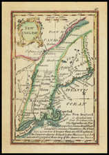
Nice early example of the first edition of Mathew Carey's map of Massachusetts, published in Carey's American Atlas in 1795 and General Atlas in 1796.
Carey's American Atlas was the first atlas published in the United States, compiling a number of excellent maps from indigenous sources in the first compilation of American maps. This map was engraved by J.T. Scott. The map shows hills, streams, county boundaries, main roads, towns and islands. Norfolk County does not appear. This rare early state can be distinguished from later states by the lack of a page number in the upper right corner. Nice margins, which is unusual for this map, which was apparently bound into an oversized example of the atlas.
An essential map for Massachusetts Collectors.


![[Right sheet only of: A New Chart of America Florida to New York with the Principal Harbours on a Large Scale, Drawn from the latest Authorities, by Robt Blachford. 1807.]](https://storage.googleapis.com/raremaps/img/small/55819.jpg)