This item has been sold, but you can enter your email address to be notified if another example becomes available.


|
||

|

|
|

|
Stock# m0604
Description
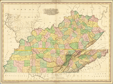
Scarce map of the KY & TN, divided by Counties and Townships. Shows roads, railroads, towns, lakes, rivers, mountains, etc. Morse's Cerographic printing process revolutionized map making and is featured in David Woodward's All American Map. An essential map for American map collectors.
![[Battle of Yorktown] Plan D'York en Virginie avec les attaques et les Campemens de l'Armee combinee de France et d'Amerique](https://storage.googleapis.com/raremaps/img/small/102603.jpg)