


|
||

|

|
|

|
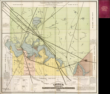
Fabulous map of the 3 states on a horizontal format, featuring a rare 4 county Wyoming and early configurations of Idaho and Montana. One of the earliest states of this map, predating the explorations in the region in the early 1870s. Shows the Overland Route to the Gold Fields, the Emigrant Road, and a host of other early roads, railroads, mines, Forts, Indians Tribes, etc. Locates Yellowstone, although the Tetons are not shown. One of the best and scarcest commercial atlas maps of this region. This is the first example of the map we have seen with the 1872 date on the map and the reference to the territories. HH Lloyd's Atlas of the United States was never issued as a separate Atlas. Its only appearance is as a supplement to County and State atlases published by Warner & Beers.

![Fly to a Holiday on Continental [Golden Jet Souvenir Flight Map]](https://storage.googleapis.com/raremaps/img/small/90328.jpg)
