This item has been sold, but you can enter your email address to be notified if another example becomes available.


|
||

|

|
|

|
Stock# m0372
Description
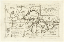
First edition of Carey's map of Canada, New England, the Great Lakes and Old Northwest Territory, from Carey's General Atlas. Extends North to Baffin's Bay and the Sea as Seen By Hearne in 1771, West to Slave Lake, Buffalo Lake, Ft. Chepawyan and the most northern bend of the Missouri River. Excellent detailed in the watershed feeding Lake Winnepeg and between the Great Lakes and James Bay. Ft. Detroit is named, along with the Northern Iroquois, Sandusky, Presq'Isle, Niagara Ft. and Falls, Oswego, Montreal, and a line showing the US Border. The Algonquin lands are also shown. A scarce early American published map of the region, engraved by Samuel Lewis.
![[ Discovery of the Northwest Passage ] Chart Showing the Recent Search for a North-West Passage. Also the Coast Explored in Search of Sir John Franklin between the Years 1848 and 1854](https://storage.googleapis.com/raremaps/img/small/101874.jpg)