This item has been sold, but you can enter your email address to be notified if another example becomes available.


|
||

|

|
|

|
Stock# m0295
Description
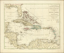
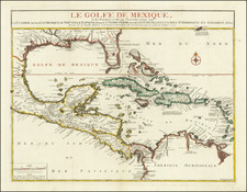
Map of the West Indies from Morse's American Geography. Shows the islands of the Caribbean in red outline color, Florida in Green, and Central and South America in yellow. Shows many islands but little detail. Despite minor offsetting and two small repaired tears in the upper margin, this is an wonderful hand colored map of the West Indies. One of the earliest maps of the Carribean printed in the United States.
![Map of Mexico, Central America, and the West Indies [Insets of Bermuda, Sandwich Islands, Jamaica and Panama Railroad]](https://storage.googleapis.com/raremaps/img/small/78369.jpg)