This item has been sold, but you can enter your email address to be notified if another example becomes available.


|
||

|

|
|

|
Stock# m0226
Description
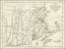
One of the earliest obtainable maps of the state. Shows counties, towns, roads, rivers, lakes, islands, ponds, bays, reefs, along with topographical details. A plan of Newport appears, as does a part of Block Island. Narrow lower right margin, which touches the neatline for approximately 1 inch. This map appeared in John Low's New and Complete American Encyclopedia.


![Belgii Pars Septentrionalis communi nomine Vulgo Hollandia…[Inset Views of New Amsterdam (New York City) & Batavia and Maps of NE United States and SE Asia]](https://storage.googleapis.com/raremaps/img/small/78398.jpg)
![Carte Du Canada ou de la Nouvelle France et des Decouvertes qui y ont ete faites . . . [Map of Canada or New France and the Discoveries Made Therein . . .]](https://storage.googleapis.com/raremaps/img/small/94450.jpg)